File:Schotts and wadis explained2.jpg

Size of this preview: 800 × 271 pixels. Other resolutions: 320 × 109 pixels | 811 × 275 pixels.
Original file (811 × 275 pixels, file size: 115 KB, MIME type: image/jpeg)
Captions
Captions
Add a one-line explanation of what this file represents
Summary
edit
| Description |
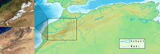
Deutsch: Das Bild zeigt zwei Fotos eines identischen Ausschnitts einiger Gebirgszüge in Marokko im Januar und im April. Die Karte zeigt die größten Flüsse, Wadis und Schotts des Atlasgebirges. Die jährliche Schneeschmelze in den schneebedeckten Hochgebirgen hat wesentlichen Anteil an der Entstehung der Wasserläufe und -Reservoirs. Español: El cuadro muestra dos fotos del mismo corte de algunos cursos de montaña en Marruecos en enero y en abril. El mapa muestra los ríos principales, los Chotts o schotts (lagos salados del norte de África) y los uadis o wadis (lechos de río secos) del sistema montañoso de Atlas. El deshielo anual de los altos montes de Atlas, cubiertos de nieve en invierno, contribuye de forma esencial al surgimiento de cursos y embalses de agua. |
| Date | |
| Source | Own work |
| Author |
|
Licensing
edit
I, the copyright holder of this work, hereby publish it under the following license:

|
Permission is granted to copy, distribute and/or modify this document under the terms of the GNU Free Documentation License, Version 1.2 or any later version published by the Free Software Foundation; with no Invariant Sections, no Front-Cover Texts, and no Back-Cover Texts. A copy of the license is included in the section entitled GNU Free Documentation License. |
| This file is licensed under the Creative Commons Attribution-Share Alike 3.0 Unported license. | ||
| ||
| This licensing tag was added to this file as part of the GFDL licensing update. |
File history
Click on a date/time to view the file as it appeared at that time.
| Date/Time | Thumbnail | Dimensions | User | Comment | |
|---|---|---|---|---|---|
| current | 22:40, 17 May 2005 | 811 × 275 (115 KB) | Homeruniverse~commonswiki (talk | contribs) | Das Bild zeigt zwei Fotos eines identischen Ausschnitts einiger Gebirgszüge in Marokko im Januar und im April. Die Karte zeigt die größten Flüße, ''Wadis'' und ''Schotts'' des Atlasgebirges. Die jährliche Schneeschmelze in den schneebedeckten Hochge |
You cannot overwrite this file.
File usage on Commons
The following page uses this file:
File usage on other wikis
The following other wikis use this file:
- Usage on af.wikipedia.org
- Usage on be.wikipedia.org
- Usage on cs.wikipedia.org
- Usage on de.wikipedia.org
- Usage on en.wikipedia.org
- Usage on eo.wikipedia.org
- Usage on es.wikipedia.org
- Usage on fa.wikipedia.org
- Usage on id.wikipedia.org
- Usage on it.wikipedia.org
- Usage on lt.wikipedia.org
- Usage on nn.wikipedia.org
- Usage on pt.wikipedia.org
- Usage on ru.wikipedia.org
- Usage on sk.wikipedia.org