File:Sea of Marmara - Admiralty Chart No 2836 Mediterranean Archipelago, Published 1863, Corrections to 1918 (cropped).tiff

Size of this JPG preview of this TIF file: 800 × 408 pixels. Other resolutions: 320 × 163 pixels | 640 × 326 pixels | 1,024 × 522 pixels | 1,280 × 653 pixels | 2,560 × 1,306 pixels | 6,332 × 3,230 pixels.
Original file (6,332 × 3,230 pixels, file size: 58.54 MB, MIME type: image/tiff)
Captions
Captions
Add a one-line explanation of what this file represents
Summary edit
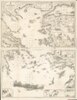
| Description |
English: William Rea Furlong was a United States Navy Rear Admiral during World War II, who also served in the Navy during World War I. The collection consists of World War I-era maps and charts. One chart from 1918 depicts German and British minefields along the coast of England and a portion of continental Europe. Other items are nautical charts of Aegean Sea with annotations. |
||
| Title | William Rea Furlong map collection. | ||
| Shelf ID | G5701.S65 coll .F8 | ||
| Parent | https://www.loc.gov/resource/g5701sm.gct00412/ | ||
| Sheet title | 1881 Admiralty Chart - Mediterranean Archipelago | ||
| Date | |||
| Source | https://www.loc.gov/item/2016586588/ | ||
| Author | Great Britain. Hydrographic Department | ||
| Permission (Reusing this file) |
|
||
| Other versions | |||
| Location | Europe · North Sea. · Aegean Sea. · North Sea · France · Europe. · Aegean Sea | ||
| Part of | Military Battles And Campaigns · American Memory · Catalog · Geography And Map Division | ||
| Subject | Europe · North Sea · Military Maps · Railroads · France · Maps · World War · Aegean Sea · Manuscript Maps |

Licensing edit
This work created by the United Kingdom Government is in the public domain.
This is because it is one of the following:
HMSO has declared that the expiry of Crown Copyrights applies worldwide (ref: HMSO Email Reply)
|
 |
File history
Click on a date/time to view the file as it appeared at that time.
| Date/Time | Thumbnail | Dimensions | User | Comment | |
|---|---|---|---|---|---|
| current | 16:01, 14 July 2020 |  | 6,332 × 3,230 (58.54 MB) | Balkanique (talk | contribs) | File:Admiralty Chart No 2836 Mediterranean Archipelago, Published 1863, Corrections to 1918.tiff cropped 47 % horizontally, 79 % vertically using CropTool with precise mode. |
You cannot overwrite this file.
File usage on Commons
The following 2 pages use this file: