File:Seacom africa map.png

Size of this preview: 629 × 600 pixels. Other resolutions: 252 × 240 pixels | 503 × 480 pixels | 691 × 659 pixels.
Original file (691 × 659 pixels, file size: 37 KB, MIME type: image/png)
Captions
Captions
Add a one-line explanation of what this file represents
Summary
edit
| Description |
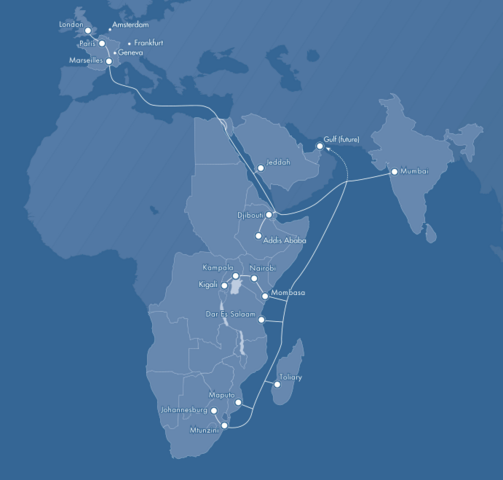
English: Seacom cable system and landing points. |
| Date | |
| Source | Own work |
| Author | Ggeldenhuys |
Licensing
edit
| I, the copyright holder of this work, release this work into the public domain. This applies worldwide. In some countries this may not be legally possible; if so: I grant anyone the right to use this work for any purpose, without any conditions, unless such conditions are required by law. |
File history
Click on a date/time to view the file as it appeared at that time.
| Date/Time | Thumbnail | Dimensions | User | Comment | |
|---|---|---|---|---|---|
| current | 12:38, 5 July 2010 | | 691 × 659 (37 KB) | Ggeldenhuys (talk | contribs) | {{Information |Description={{en|1=Seacom cable system and landing points.}} |Source={{own}} |Author=Ggeldenhuys |Date=2010-07-05 |Permission= |other_versions= }} |
You cannot overwrite this file.
File usage on Commons
There are no pages that use this file.