File:Selter Grundriss von Berlin 1846 (georeferenced) (Blumenstraße).jpg

Original file (2,303 × 1,483 pixels, file size: 1.18 MB, MIME type: image/jpeg)
Captions
Captions
| Description |
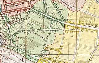
Grundriss von Berlin Aufgenommen und gezeichnet mit Genehmigung der Königl. Academie der Wissenschaften von J.C.Selter. Im Verlage bei Simon Schropp et Comp 1846.
Der Titel steht rechts oben in einer ovalen Umrandung. Der Rahmen enthält Längen- und Breitengrade (nach Ferro) - die Position des alten Observatoriums auf dem Marstall ist besonders hervorgehoben. In der inneren Rahmenleiste ist ein fortlaufender Maßstab eingebettet. Links unten ist ein Rechteck eingezogen mit einer Maßstabsleiste über 150 Ruthen. Die Teilstädte sind durch unterschiedliche Farben grafisch unterschieden. In den Grundstücken sind die Hausnummer tw. eingetragen. Mit einer rot/schwarze-gestrichelten Signatur sind die 26 Polizeireviere abgegrenzt und nummeriert. |
| Date | |
| Source | Zentral- und Landesbibliothek Berlin |
| Author |
Jean Chrétien Selter
|
| Other versions |
|
.jpg)

| Open this image as an overlay in Google Earth (Google Maps, Bing) | (Help|Source) |
_(Blumenstra%C3%9Fe).jpg/overlay.kml&action=edit&redlink=1)
|
This work is in the public domain in its country of origin and other countries and areas where the copyright term is the author's life plus 100 years or fewer. | |
| This file has been identified as being free of known restrictions under copyright law, including all related and neighboring rights. | |
File history
Click on a date/time to view the file as it appeared at that time.
| Date/Time | Thumbnail | Dimensions | User | Comment | |
|---|---|---|---|---|---|
| current | 12:33, 7 June 2019 | | 2,303 × 1,483 (1.18 MB) | Boonekamp (talk | contribs) | File:Selter Grundriss von Berlin 1846 (georeferenced).jpg cropped 76 % horizontally, 80 % vertically using CropTool with precise mode. |
You cannot overwrite this file.
File usage on Commons
The following page uses this file:
File usage on other wikis
The following other wikis use this file:
- Usage on de.wikipedia.org
_(Blumenstraße).jpg&oldid=663963937)