File:Sendai City Panorama from Atago Shrine 2010-06-06 cropped-2.jpg
Size of this preview: 800 × 252 pixels. Other resolutions: 320 × 101 pixels | 640 × 201 pixels | 1,024 × 322 pixels | 1,280 × 403 pixels | 5,400 × 1,700 pixels.
Original file (5,400 × 1,700 pixels, file size: 4.14 MB, MIME type: image/jpeg)
File information
Structured data
Captions
DescriptionSendai City Panorama from Atago Shrine 2010-06-06 cropped-2.jpg |
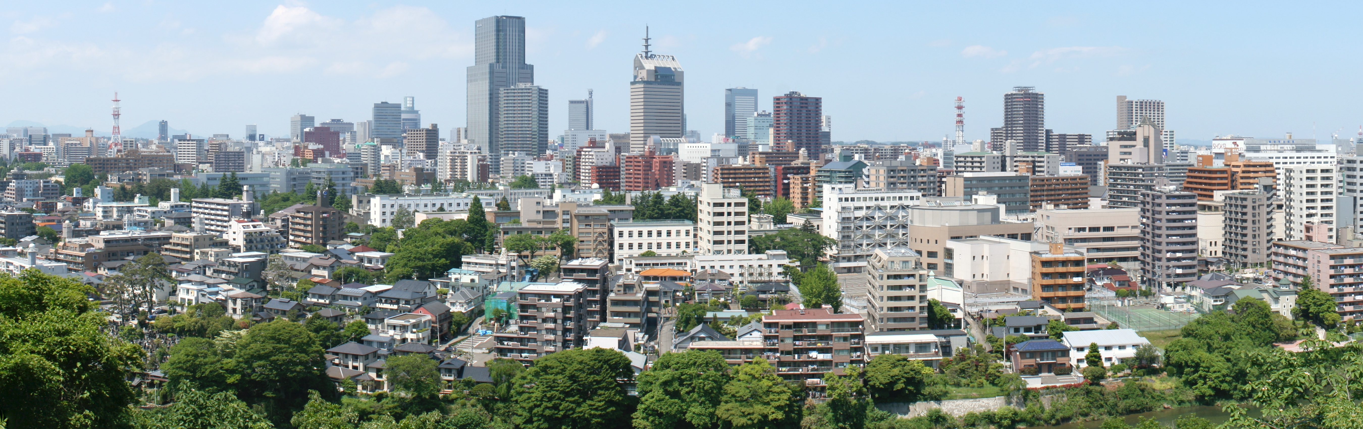
English: Panoramic view of Sendai City viewed from Atago Shrine at Mt. Atago in Mukaiyama 4 chōme, Taihaku Ward, Sendai City, Miyagi Prefecture, Japan. Stitched 6 photographs together by Hugin, and retouched by GIMP2.
|
|||
Date | ||||
Source | Own work | |||
Author | Enirac Sum | |||
Permission (Reusing this file) |
|
|||
Other versions |
Derivative works of this file: |
This is a retouched picture, which means that it has been digitally altered from its original version. Modifications: cropped. The original can be viewed here: Sendai City Panorama from Atago Shrine 2010-06-06.jpg: . Modifications made by Enirac Sum.
|
Camera location | 38° 14′ 45.27″ N, 140° 52′ 33.31″ E | View this and other nearby images on: OpenStreetMap | 38.245908; 140.875919 |
---|
This image was created with Hugin.
620
466
55
100
5400
1700
日本語: シティタワー勾当台通
English: City Tower Kōtōdai Avenue
966
485
59
74
5400
1700
日本語: ライオンズタワー勾当台通
{{en|Lions Tower Kōtōdai Avenue}
1402
468
82
112
5400
1700
日本語: 仙台本町三井ビルディング
English: Sendai Honchō Mitsui Building
1778
499
39
72
5400
1700
日本語: パークタワー台原
English: Park Tower Dainohara
2238
340
127
189
5400
1700
日本語: 東北電力本店ビル (エナジースクエア)
English: Tōhoku Electric Power Main Office Building (Energy Square)
2475
79
259
550
5400
1700
日本語: 住友生命仙台中央ビル (SS30)
English: Sumitomo Life Sendai Central Building (SS30)
3957
326
199
288
5400
1700
日本語: アップルタワーズ仙台ブローディアタワー
English: Apple Towers Sendai Brodia Tower
File history
Click on a date/time to view the file as it appeared at that time.
Date/Time | Thumbnail | Dimensions | User | Comment | |
---|---|---|---|---|---|
current | 01:38, 9 August 2010 | 5,400 × 1,700 (4.14 MB) | Enirac Sum (talk | contribs) | {{Information |Description={{en|1=Panoramic view of Sendai City viewed from Atago Shrine at Mt. Atago in Mukaiyama 4 chōme, Taihaku Ward, Sendai City, Miyagi Prefecture, Japan. Stitched 6 photographs together by Hugin, and retouched by GIM |
You cannot overwrite this file.
File usage on Commons
The following page uses this file:
File usage on other wikis
The following other wikis use this file:
- Usage on ru.wikivoyage.org
Metadata
This file contains additional information such as Exif metadata which may have been added by the digital camera, scanner, or software program used to create or digitize it. If the file has been modified from its original state, some details such as the timestamp may not fully reflect those of the original file. The timestamp is only as accurate as the clock in the camera, and it may be completely wrong.
Camera manufacturer | Canon |
---|---|
Camera model | Canon EOS Kiss Digital X |
Author | Enirac Sum |
Copyright holder | Enirac Sum |
Exposure time | 1/125 sec (0.008) |
F-number | f/11 |
ISO speed rating | 100 |
Date and time of data generation | 13:00, 6 June 2010 |
Lens focal length | 25 mm |
Orientation | Normal |
Horizontal resolution | 72 dpi |
Vertical resolution | 72 dpi |
File change date and time | 13:00, 6 June 2010 |
Y and C positioning | Co-sited |
Exposure Program | Manual |
Exif version | 2.21 |
Date and time of digitizing | 13:00, 6 June 2010 |
APEX shutter speed | 6.9657897949219 |
APEX aperture | 6.9188690185547 |
APEX exposure bias | 0 |
Metering mode | Average |
Flash | Flash did not fire, compulsory flash suppression |
Color space | sRGB |
Focal plane X resolution | 4,433.2953249715 |
Focal plane Y resolution | 4,453.6082474227 |
Focal plane resolution unit | inches |
Custom image processing | Normal process |
Exposure mode | Manual exposure |
White balance | Manual white balance |
Scene capture type | Standard |