File:Seven+Summits+Elevation+World+Map.png
Size of this preview: 800 × 400 pixels. Other resolutions: 320 × 160 pixels | 640 × 320 pixels | 1,524 × 762 pixels.
Original file (1,524 × 762 pixels, file size: 1.77 MB, MIME type: image/png)
Captions
Captions
Add a one-line explanation of what this file represents
Summary
edit
| Description |
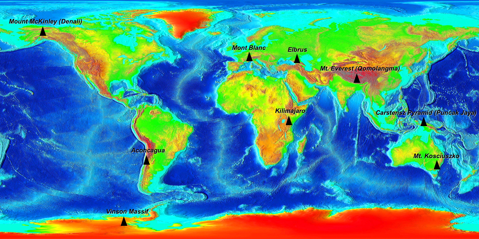
The Seven Summits on an Elevation World Map. (For more information on why 9 peaks are on this map read the wikipedia Seven Summits article.) Elevation key: Green < 500m, Yellow <1000m, Orange <2000m, Red <3000m, Dark Red <5000m, Grey >5000m |
| Date | |
| Source |
Own work based on Image:Elevation.jpg Original file from https://www.ngdc.noaa.gov/mgg/image/2minrelief.html |
| Author |
Base image: National Oceanic and Atmospheric Administration Tagged: Ma xyz |
| Permission (Reusing this file) |
PD |
Licensing
edit
| I, the copyright holder of this work, release this work into the public domain. This applies worldwide. In some countries this may not be legally possible; if so: I grant anyone the right to use this work for any purpose, without any conditions, unless such conditions are required by law. |
File history
Click on a date/time to view the file as it appeared at that time.
| Date/Time | Thumbnail | Dimensions | User | Comment | |
|---|---|---|---|---|---|
| current | 03:29, 10 August 2006 | | 1,524 × 762 (1.77 MB) | Ma xyz (talk | contribs) | {{Information |Description=The Seven Summits on an Elevation World Map |Source=own work based on Image:Elevation.jpg |Date=2006-08-09 |Author=The Uploader |Permission=PD |other_versions= }} |
| 03:07, 10 August 2006 |  | 1,525 × 763 (1.78 MB) | Ma xyz (talk | contribs) | {{Information |Description=The Seven Summits on an Elevation World Map |Source=own work based on Image:Elevation.jpg |Date=2006-08-09 |Author=The Uploader |Permission=PD |other_versions= }} |
You cannot overwrite this file.
File usage on Commons
The following page uses this file:
File usage on other wikis
The following other wikis use this file:
- Usage on ar.wikipedia.org
- Usage on ast.wikipedia.org
- Usage on be-tarask.wikipedia.org
- Usage on be.wikipedia.org
- Usage on bn.wikipedia.org
- Usage on ca.wikipedia.org
- Usage on cs.wikipedia.org
- Usage on da.wikipedia.org
- Usage on de.wikipedia.org
- Usage on en.wikipedia.org
- Usage on es.wikipedia.org
- Usage on et.wikipedia.org
- Usage on eu.wikipedia.org
- Usage on fa.wikipedia.org
- Usage on fi.wikipedia.org
- Usage on gl.wikipedia.org
- Usage on he.wikipedia.org
- Usage on hi.wikipedia.org
- Usage on id.wikipedia.org
- Usage on inh.wikipedia.org
- Usage on it.wikipedia.org
- Usage on ja.wikipedia.org
- Usage on kk.wikipedia.org
- Usage on nl.wikipedia.org
- Usage on nn.wikipedia.org
- Usage on no.wikipedia.org
- Usage on pl.wikipedia.org
- Usage on pl.wikiquote.org
- Usage on pl.wiktionary.org
- Usage on ro.wikipedia.org
- Usage on ru.wikipedia.org
- Usage on sd.wikipedia.org
- Usage on sk.wikipedia.org
- Usage on sl.wikipedia.org
- Usage on sr.wikipedia.org
- Usage on sv.wikipedia.org
- Usage on tr.wikipedia.org
- Usage on ur.wikipedia.org
- Usage on www.wikidata.org
- Usage on zh.wikipedia.org