File:Seville, Spain ESA21469794.tiff
Original file (14,198 × 13,837 pixels, file size: 562.1 MB, MIME type: image/tiff)
Captions
Captions
Summary edit
| Warning | The original file is very high-resolution. It might not load properly or could cause your browser to freeze when opened at full size. |
|---|
| Description |
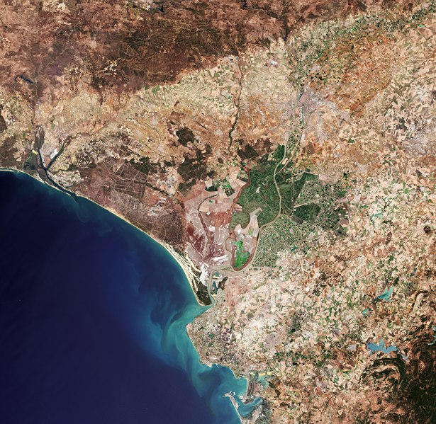
English: Ahead of next week’s ‘Space19+’ Ministerial Council, the Copernicus Sentinel-2 mission takes us over Seville in southern Spain – the destination for this milestone event. On 27–28 November, Ministers from ESA’s Member States along with Associate Member Slovenia and Cooperating State Canada will meet in Seville for the ESA Council at Ministerial Level Space19+ to discuss future space activities for Europe and the budget of Europe’s space agency for the coming three years. Space19+ is an opportunity to direct Europe’s ‘next generation’ ambitions in space, and address the challenges facing not only the European space sector, but also European society as a whole. Seville, visible towards the top right of this image, is the capital of Andalusia and the fourth largest city in Spain. An inland port, it lies on the Guadalquivir River and while the original course of the river is visible snaking through the city on the right, we can see where water has also been redirected into a straighter course on the left. At over 650 km long, the Guadalquivir is one of the longest rivers in Spain, extending way beyond the frame of this image. Nevertheless, it can be seen winding its course all the way from the top right of the image, just south of the Sierra Norte mountain range, to the Gulf of Cádiz where it empties into the Atlantic Ocean. On route, this major river serves as a source for irrigation – here noticeable in the top right of the image, but mainly to the south of Seville where large green agricultural fields appear in sharp contrast to the surrounding drier brown land. The Doñana National Park lies on the right bank of the Guadalquivir River, at its estuary on the Atlantic Ocean. One of Europe's most important wetland reserves, the park is an area of marsh, shallow streams and sand dunes, and an important site for endangered and migrating birds. Copernicus Sentinel-2 is a two-satellite mission. Each satellite carries a high-resolution camera that images Earth’s surface in 13 spectral bands. Data from Copernicus Sentinel-2 are used to monitor changes in land cover, agriculture, and coastal and inland waters. This image, captured on 21 June 2019, is also featured on the Earth from Space video programme. |
| Date | 22 November 2019 (upload date) |
| Source | Seville, Spain |
| Author | European Space Agency |
| Other versions |
|
| Activity | Observing the Earth |
| Mission | Sentinel-2 |
| Set | Earth observation image of the week |
| System | Copernicus |

Licensing edit

|
This image contains data from a satellite in the Copernicus Programme, such as Sentinel-1, Sentinel-2 or Sentinel-3. Attribution is required when using this image.
Attribution: Contains modified Copernicus Sentinel data 2019
The use of Copernicus Sentinel Data is regulated under EU law (Commission Delegated Regulation (EU) No 1159/2013 and Regulation (EU) No 377/2014). Relevant excerpts:
Free access shall be given to GMES dedicated data [...] made available through GMES dissemination platforms [...].
Access to GMES dedicated data [...] shall be given for the purpose of the following use in so far as it is lawful:
GMES dedicated data [...] may be used worldwide without limitations in time.
GMES dedicated data and GMES service information are provided to users without any express or implied warranty, including as regards quality and suitability for any purpose. |
This media was created by the European Space Agency (ESA).
Where expressly so stated, images or videos are covered by the Creative Commons Attribution-ShareAlike 3.0 IGO (CC BY-SA 3.0 IGO) licence, ESA being an Intergovernmental Organisation (IGO), as defined by the CC BY-SA 3.0 IGO licence. The user is allowed under the terms and conditions of the CC BY-SA 3.0 IGO license to Reproduce, Distribute and Publicly Perform the ESA images and videos released under CC BY-SA 3.0 IGO licence and the Adaptations thereof, without further explicit permission being necessary, for as long as the user complies with the conditions and restrictions set forth in the CC BY-SA 3.0 IGO licence, these including that:
See the ESA Creative Commons copyright notice for complete information, and this article for additional details.
|
 | |
This file is licensed under the Creative Commons Attribution-ShareAlike 3.0 IGO license. Attribution: ESA, CC BY-SA IGO 3.0
| ||
File history
Click on a date/time to view the file as it appeared at that time.
| Date/Time | Thumbnail | Dimensions | User | Comment | |
|---|---|---|---|---|---|
| current | 12:55, 7 June 2020 |  | 14,198 × 13,837 (562.1 MB) | OptimusPrimeBot (talk | contribs) | #Spacemedia - Upload of https://esamultimedia.esa.int/img/2019/11/Sevilla_mosaic_Sentinel-2_21june2019_432_enhanced_ML.tif via Commons:Spacemedia |
You cannot overwrite this file.
File usage on Commons
The following page uses this file:
_Seville,_Spain_(49104522676)_(cropped).jpg)