File:Shanghai Rail Transit Network.png

Size of this preview: 685 × 599 pixels. Other resolutions: 274 × 240 pixels | 549 × 480 pixels | 878 × 768 pixels | 1,170 × 1,024 pixels | 2,341 × 2,048 pixels | 4,000 × 3,500 pixels.
Original file (4,000 × 3,500 pixels, file size: 1.57 MB, MIME type: image/png)
Captions
Captions
Add a one-line explanation of what this file represents
Summary edit
| Description |
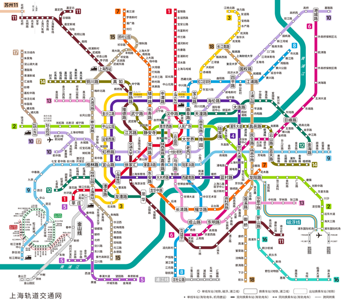
English: the rail transit network in Shanghai |
| Date | |
| Source | Own work |
| Author | Alan Fan Pei |
Licensing edit
I, the copyright holder of this work, hereby publish it under the following license:
This file is licensed under the Creative Commons Attribution-Share Alike 4.0 International license.
- You are free:
- to share – to copy, distribute and transmit the work
- to remix – to adapt the work
- Under the following conditions:
- attribution – You must give appropriate credit, provide a link to the license, and indicate if changes were made. You may do so in any reasonable manner, but not in any way that suggests the licensor endorses you or your use.
- share alike – If you remix, transform, or build upon the material, you must distribute your contributions under the same or compatible license as the original.
File history
Click on a date/time to view the file as it appeared at that time.
| Date/Time | Thumbnail | Dimensions | User | Comment | |
|---|---|---|---|---|---|
| current | 08:15, 6 July 2023 | | 4,000 × 3,500 (1.57 MB) | Alan Fan Pei (talk | contribs) | Transfer info for Suzhou RT L11 added |
| 06:55, 27 May 2023 |  | 4,000 × 3,550 (1.59 MB) | Alan Fan Pei (talk | contribs) | Zhangjiang Line service ends on 2023-05-30 | |
| 03:49, 29 December 2021 |  | 4,000 × 3,548 (1.61 MB) | Alan Fan Pei (talk | contribs) | Line 14, line 18 north section added | |
| 14:29, 24 June 2021 |  | 4,001 × 3,451 (1.5 MB) | Alan Fan Pei (talk | contribs) | Mapping improved | |
| 13:56, 13 June 2021 |  | 4,000 × 3,505 (1.51 MB) | Alan Fan Pei (talk | contribs) | Mapping improved | |
| 12:26, 26 February 2021 |  | 4,004 × 3,542 (1.52 MB) | Alan Fan Pei (talk | contribs) | Mapping improved | |
| 08:06, 7 February 2021 |  | 3,200 × 2,831 (2.14 MB) | Alan Fan Pei (talk | contribs) | Uploaded own work with UploadWizard |
You cannot overwrite this file.
File usage on Commons
The following 12 pages use this file:
- User:Chumwa/OgreBot/Public transport information/2021 December 21-31
- User:Chumwa/OgreBot/Public transport information/2021 February 1-9
- User:Chumwa/OgreBot/Public transport information/2021 February 19-28
- User:Chumwa/OgreBot/Public transport information/2021 June 21-30
- User:Chumwa/OgreBot/Public transport information/2023 July 1-10
- User:Chumwa/OgreBot/Public transport information/2023 May 21-31
- User:Chumwa/OgreBot/Transport Maps/2021 December 21-31
- User:Chumwa/OgreBot/Transport Maps/2021 February 1-9
- User:Chumwa/OgreBot/Transport Maps/2021 February 19-28
- User:Chumwa/OgreBot/Transport Maps/2021 June 21-30
- User:Chumwa/OgreBot/Transport Maps/2023 July 1-10
- User:Chumwa/OgreBot/Transport Maps/2023 May 21-31