File:Sheet 5 (41672016151).jpg

Original file (7,115 × 5,686 pixels, file size: 5.06 MB, MIME type: image/jpeg)
Captions
Captions
Summary
edit.jpg&action=edit§ion=1)
| Description |
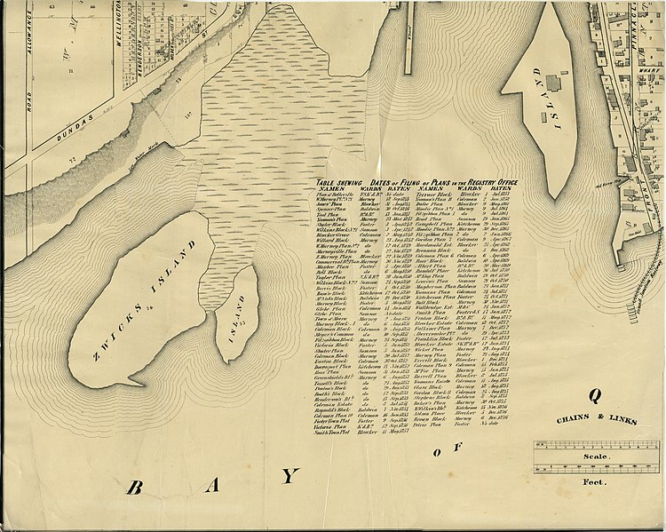
Part of the 1877 Map of the City of Belleville, Township of Thurlow, County of Hastings, Ontario, by Evans & Bolger, surveyors. Includes list of plans filed with the Hastings County Registry Office and the date they were filed. |
| Date | |
| Source | Sheet 5 |
| Author | Community Archives |
| Camera location | | View this and other nearby images on: OpenStreetMap |
|---|
.jpg¶ms=044.155638_N_-077.388188_E_globe:Earth_type:camera_source:Flickr_&language=en)
Licensing
edit.jpg&action=edit§ion=2)
This Canadian work is in the public domain in Canada because its copyright has expired due to one of the following:
it was not subject to Crown copyright, and
|
 |
| This image was originally posted to Flickr by Community Archives of Belleville & Hastings County at https://flickr.com/photos/134017397@N03/41672016151 (archive). It was reviewed on 25 October 2019 by FlickreviewR 2 and was confirmed to be licensed under the terms of the Public Domain Mark. |
File history
Click on a date/time to view the file as it appeared at that time.
| Date/Time | Thumbnail | Dimensions | User | Comment | |
|---|---|---|---|---|---|
| current | 22:41, 26 April 2018 | | 7,115 × 5,686 (5.06 MB) | Mindmatrix (talk | contribs) | Transferred from Flickr via #flickr2commons |
You cannot overwrite this file.
File usage on Commons
There are no pages that use this file.
.jpg&oldid=814750349)