File:Sherburne Co Chart 2015 No Text Version.pdf

Size of this JPG preview of this PDF file: 776 × 600 pixels. Other resolutions: 311 × 240 pixels | 621 × 480 pixels | 994 × 768 pixels | 1,280 × 989 pixels | 1,650 × 1,275 pixels.
Original file (1,650 × 1,275 pixels, file size: 6 KB, MIME type: application/pdf)
Captions
Captions
Add a one-line explanation of what this file represents
Summary edit
| Description |
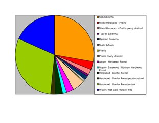
English: Sherburne County Minnesota Savanna Soils 36 % Type III Savannas are forest soils without prairie characteristics (mollic epipedon) that support native grasses and trees. Sourced-from: Web Soil Survey (WSS), Natural Resources Conservation Service, United States Department of Agriculture. Available online at http://websoilsurvey.nrcs.usda.gov/. NRCS/WSS native vegetation information first sorted by soil series then compiled using soil series proportion of county area (%). Accessed by Steve Nelson 3-31-15 |
| Date | |
| Source | Own work |
| Author | Wood Geek |
Licensing edit
I, the copyright holder of this work, hereby publish it under the following license:
This file is licensed under the Creative Commons Attribution-Share Alike 4.0 International license.
- You are free:
- to share – to copy, distribute and transmit the work
- to remix – to adapt the work
- Under the following conditions:
- attribution – You must give appropriate credit, provide a link to the license, and indicate if changes were made. You may do so in any reasonable manner, but not in any way that suggests the licensor endorses you or your use.
- share alike – If you remix, transform, or build upon the material, you must distribute your contributions under the same or compatible license as the original.
File history
Click on a date/time to view the file as it appeared at that time.
| Date/Time | Thumbnail | Dimensions | User | Comment | |
|---|---|---|---|---|---|
| current | 15:52, 1 April 2015 |  | 1,650 × 1,275 (6 KB) | Wood Geek (talk | contribs) | User created page with UploadWizard |
You cannot overwrite this file.
File usage on Commons
There are no pages that use this file.
File usage on other wikis
The following other wikis use this file:
- Usage on en.wikipedia.org