File:Shirley Windmill.jpg

Size of this preview: 378 × 599 pixels. Other resolutions: 151 × 240 pixels | 404 × 640 pixels.
Original file (404 × 640 pixels, file size: 119 KB, MIME type: image/jpeg)
Captions
Captions
Add a one-line explanation of what this file represents
Summary
edit
| Description |
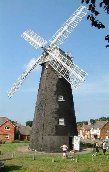
English: Shirley Windmill in Post Mill Close, off Upper Shirley Road, Croydon, Greater London. Croydon's only windmill. Built in the mid 1850's to replace an earlier post mill which was destroyed by fire in 1854, it worked until 1892 when it was abandoned. The mill is opened on the first Sunday of each month from June until October, between 13:00 and 17:00. |
| Date | |
| Source | From this image at geograph.org.uk |
| Author | Philip Talmage |
| Permission (Reusing this file) |
Creative Commons Attribution Share-alike license 2.0 |
| Object location | | View this and other nearby images on: OpenStreetMap |
|---|
_region:GB-ENG_&language=en)

|
This image was taken from the Geograph project collection. See this photograph's page on the Geograph website for the photographer's contact details. The copyright on this image is owned by Philip Talmage and is licensed for reuse under the Creative Commons Attribution-ShareAlike 2.0 license.
|
This file is licensed under the Creative Commons Attribution-Share Alike 2.0 Generic license.
Attribution: Philip Talmage
- You are free:
- to share – to copy, distribute and transmit the work
- to remix – to adapt the work
- Under the following conditions:
- attribution – You must give appropriate credit, provide a link to the license, and indicate if changes were made. You may do so in any reasonable manner, but not in any way that suggests the licensor endorses you or your use.
- share alike – If you remix, transform, or build upon the material, you must distribute your contributions under the same or compatible license as the original.
File history
Click on a date/time to view the file as it appeared at that time.
| Date/Time | Thumbnail | Dimensions | User | Comment | |
|---|---|---|---|---|---|
| current | 23:28, 24 November 2007 | | 404 × 640 (119 KB) | Lamberhurst (talk | contribs) | {{geograph|032294|Philip Talmage}} Shirley Windmill Category:Windmills in England |
You cannot overwrite this file.
File usage on Commons
The following page uses this file:
File usage on other wikis
The following other wikis use this file:
- Usage on azb.wikipedia.org
- Usage on en.wikipedia.org
- Usage on en.wikivoyage.org
- Usage on eu.wikipedia.org
- Usage on he.wikivoyage.org
- Usage on it.wikivoyage.org
- Usage on nl.wikipedia.org
- Usage on uz.wikipedia.org
- Usage on www.wikidata.org