File:Showrick Bridge - geograph.org.uk - 149283.jpg
No higher resolution available.
Showrick_Bridge_-_geograph.org.uk_-_149283.jpg (640 × 480 pixels, file size: 124 KB, MIME type: image/jpeg)
Captions
Captions
Add a one-line explanation of what this file represents
Summary edit
| Description |
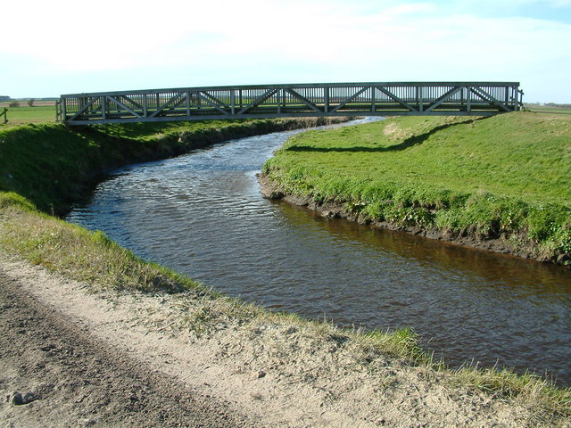
English: Showrick Bridge. Large foot bridge over the River Alt on a footpath from Bells Lane Lydiate to Sefton and Lunt.
There has been a bridge here from as early as the 18th century. The bridge was destroyed for military reasons in 1915 by the armed forces, it is not known what the reasons were. The bridge was not replaced after the war. In 1959 following historical research by The Ramblers Association, a public inquiry established that the footpaths between Sefton and Lunt Village and Bells Lane Lydiate were public footpaths. The new Showrick Bridge was built by Sefton Council in partnership with Lancashire County Council in 1998 with grant support from the Countryside Commission and The Environment Agency. |
| Date | |
| Source | From geograph.org.uk |
| Author | Peter Hodge |
| Attribution (required by the license) | Peter Hodge / Showrick Bridge / |
| Object location | | View this and other nearby images on: OpenStreetMap |
|---|
_heading:315.00&language=en)
Licensing edit

|
This image was taken from the Geograph project collection. See this photograph's page on the Geograph website for the photographer's contact details. The copyright on this image is owned by Peter Hodge and is licensed for reuse under the Creative Commons Attribution-ShareAlike 2.0 license.
|
This file is licensed under the Creative Commons Attribution-Share Alike 2.0 Generic license.
Attribution: Peter Hodge
- You are free:
- to share – to copy, distribute and transmit the work
- to remix – to adapt the work
- Under the following conditions:
- attribution – You must give appropriate credit, provide a link to the license, and indicate if changes were made. You may do so in any reasonable manner, but not in any way that suggests the licensor endorses you or your use.
- share alike – If you remix, transform, or build upon the material, you must distribute your contributions under the same or compatible license as the original.
File history
Click on a date/time to view the file as it appeared at that time.
| Date/Time | Thumbnail | Dimensions | User | Comment | |
|---|---|---|---|---|---|
| current | 09:33, 31 January 2010 | | 640 × 480 (124 KB) | GeographBot (talk | contribs) | == {{int:filedesc}} == {{Information |description={{en|1=Showrick Bridge. Large foot bridge over the River Alt on a footpath from Bells Lane Lydiate to Sefton and Lunt. There has been a bridge here from as early as the 18th century. The bridge was destr |
You cannot overwrite this file.
File usage on Commons
There are no pages that use this file.