File:Sicily (MODIS).jpg

Size of this preview: 720 × 599 pixels. Other resolutions: 288 × 240 pixels | 577 × 480 pixels | 923 × 768 pixels | 1,230 × 1,024 pixels | 1,921 × 1,599 pixels.
Original file (1,921 × 1,599 pixels, file size: 712 KB, MIME type: image/jpeg)
Captions
Captions
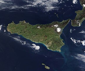
The triangular-shaped island of Sicily sits at the heart of the Mediterranean Sea, positioned roughly 100 miles (160 km) north of Tunisia, in north Africa, and just 2 miles (3 km) from the southern tip of mainland Italy.
Summary
edit.jpg&action=edit§ion=1)
| Description |
English: The triangular-shaped island of Sicily sits at the heart of the Mediterranean Sea, positioned roughly 100 miles (160 km) north of Tunisia, in north Africa, and just 2 miles (3 km) from the southern tip of mainland Italy. This strategic location has placed the Mediterranean’s largest island at the crossroads of history for many thousands of years and through a variety of civilizations. The island has been inhabited for at least 10,000 years.
On February 22, the Moderate Resolution Imaging Spectroradiometer (MODIS) on board NASA’s Terra satellite acquired a true-color image of Sicily surrounded by the blue waters of the Mediterranean Sea, colored in green, and the highest peaks topped with winter snow. In the east, a light gray plume can be seen rising from Sicily’s most iconic feature, Mount Etna, and blowing towards the southeast over the Mediterranean. Standing at 3,329 meters high (10,922 feet), the volcano is in almost continuous eruption. In late November 2022 a new fissure vent opened on Etna’s southeast crater, permitting lava to flow and beginning a new effusive eruption. On February 8, 2023, the volcano observatory in Catania released a bulletin for aviation services mentioning that the effusive eruption at the summit craters had ended. Low level activity above background levels have continued, with very little ash emission. The light gray plume captured in this image is likely primarily volcanic gases with little ash. |
||
| Date | Taken on 22 February 2023 | ||
| Source |
|
||
| Author | MODIS Land Rapid Response Team, NASA GSFC |
| This media is a product of the Terra mission Credit and attribution belongs to the mission team, if not already specified in the "author" row |
Licensing
edit.jpg&action=edit§ion=2)
| This file is in the public domain in the United States because it was solely created by NASA. NASA copyright policy states that "NASA material is not protected by copyright unless noted". (See Template:PD-USGov, NASA copyright policy page or JPL Image Use Policy.) | ||
 |
Warnings:
|
File history
Click on a date/time to view the file as it appeared at that time.
| Date/Time | Thumbnail | Dimensions | User | Comment | |
|---|---|---|---|---|---|
| current | 20:03, 31 July 2023 | | 1,921 × 1,599 (712 KB) | OptimusPrimeBot (talk | contribs) | #Spacemedia - Upload of http://modis.gsfc.nasa.gov/gallery/images/image02232023_250m.jpg via Commons:Spacemedia |
You cannot overwrite this file.
File usage on Commons
There are no pages that use this file.
.jpg&oldid=821762078)