File:Sierran Arc Subduction.png
No higher resolution available.
Sierran_Arc_Subduction.png (437 × 178 pixels, file size: 40 KB, MIME type: image/png)
Captions
Captions
Add a one-line explanation of what this file represents
Summary
edit
| Description |
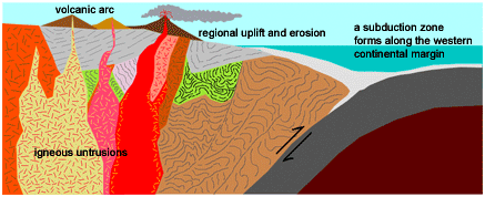
English: Original caption: Plate convergence along the continental margin produced a volcanic arc system throughout the Sierra Nevada and Mojave region roughly 250 million to about 60 million years ago |
| Date | |
| Source | Archived source link |
| Author | Western Earth Surface Processes Team |
| Permission (Reusing this file) |
PD-USGov-USGS |
| Other versions | higher-res gif |
Licensing
edit
This image is in the public domain in the United States because it only contains materials that originally came from the United States Geological Survey, an agency of the United States Department of the Interior. For more information, see the official USGS copyright policy.
|
File history
Click on a date/time to view the file as it appeared at that time.
| Date/Time | Thumbnail | Dimensions | User | Comment | |
|---|---|---|---|---|---|
| current | 20:45, 4 August 2008 | 437 × 178 (40 KB) | Hike395 (talk | contribs) | {{Information |Description={{en|1=Original caption: Plate convergence along the continental margin produced a volcanic arc system throughout the Sierra Nevada and Mojave region roughly 250 million to about 60 million years ago}} |Source=http://geomaps.wr. |
You cannot overwrite this file.
File usage on Commons
There are no pages that use this file.