File:SihaiHuayiZongtu.jpg

Original file (2,331 × 1,746 pixels, file size: 742 KB, MIME type: image/jpeg)
Captions
Captions
Summary
edit
| Description |
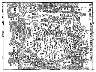
English: The "Complete Map of the 4 Seas, China, and Barbarians" (四海華夷總圖, 四海华夷总图, Sihai Huayi Zongtu)
Français : Carte de la Chine de 1532, « Sihai hua yi zong tu » (四海華夷總圖/四海华夷总图, « Vue d'ensemble des quatre mer de Chine »), impression xylographqique.
中文:四海華夷總圖/四海华夷总图,1532年 |
| Date | |
| Source | Harvard Library |
| Author | Unknown author |
Licensing
edit
|
This work is in the public domain in its country of origin and other countries and areas where the copyright term is the author's life plus 70 years or fewer.
| |
| This file has been identified as being free of known restrictions under copyright law, including all related and neighboring rights. | |
This work is in the public domain in the United States because it was published (or registered with the U.S. Copyright Office) before January 1, 1929.
Public domain works must be out of copyright in both the United States and in the source country of the work in order to be hosted on the Commons. If the work is not a U.S. work, the file must have an additional copyright tag indicating the copyright status in the source country.
Note: This tag should not be used for sound recordings. |
| Annotations | This image is annotated: View the annotations at Commons |
File history
Click on a date/time to view the file as it appeared at that time.
| Date/Time | Thumbnail | Dimensions | User | Comment | |
|---|---|---|---|---|---|
| current | 05:08, 13 August 2007 | | 2,331 × 1,746 (742 KB) | World Imaging (talk | contribs) | {{Information |Description=Ancient Chinese map "Sihaihuayizongtu", 1532 |Source=Harvard Library |Date=2007 |Author=Unknown }} |
You cannot overwrite this file.
File usage on Commons
There are no pages that use this file.
File usage on other wikis
The following other wikis use this file:
- Usage on be.wikipedia.org
- Usage on ca.wikipedia.org
- Usage on de.wikipedia.org
- Usage on en.wikipedia.org
- Usage on eo.wikipedia.org
- Usage on es.wikipedia.org
- Usage on fi.wikipedia.org
- Usage on fr.wikipedia.org
- Usage on hy.wikipedia.org
- Usage on id.wikipedia.org
- Usage on it.wikipedia.org
- Usage on ja.wikipedia.org
- Usage on ko.wikipedia.org
- Usage on nl.wikipedia.org
- Usage on no.wikipedia.org
- Usage on pl.wikipedia.org
- Usage on pnb.wikipedia.org
- Usage on pt.wikipedia.org
- Usage on ro.wikipedia.org
- Usage on ru.wikipedia.org
- Usage on ur.wikipedia.org
- Usage on vi.wikipedia.org
- Usage on www.wikidata.org
- Usage on zh-min-nan.wikipedia.org
- Usage on zh.wikipedia.org