File:Silala en mapa 1904.png
No higher resolution available.
Silala_en_mapa_1904.png (470 × 404 pixels, file size: 491 KB, MIME type: image/png)
Captions
Captions
Add a one-line explanation of what this file represents
| Description |
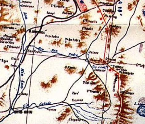
English: Extract of the provisional map with the border demarcation between Chile and Bolivia according to the 1904 peace treaty. The extract focuses on the area of the current Silala dispute between both countries.
Español: Extracto del plano provisional con la demarcación de frontera entre Chile y Bolivia según el Tratado de Paz y Amistad de 1904. El extracto enfoca el área donde se encuentra la disputa por el Silala entre ambos países. |
|||
| Date | ||||
| Source | File:Plano_provisorio_frontera_Chile-bolivia_1904.jpg | |||
| Author | Lit. Suiza, Santiago | |||
| Permission (Reusing this file) |
|
|||
| Other versions |
|

File history
Click on a date/time to view the file as it appeared at that time.
| Date/Time | Thumbnail | Dimensions | User | Comment | |
|---|---|---|---|---|---|
| current | 16:06, 3 April 2016 | | 470 × 404 (491 KB) | B1mbo (talk | contribs) | {{Information |Description ={{en|1=Extract of the provisional map with the border demarcation between Chile and Bolivia according to the 1904 peace treaty. The extract focuses on the area of the current Silala dispute between both countries.}} {{es|... |
You cannot overwrite this file.
File usage on Commons
The following page uses this file:
File usage on other wikis
The following other wikis use this file:
- Usage on es.wikipedia.org