File:SimcoeMunicipalityMap.png
No higher resolution available.
SimcoeMunicipalityMap.png (384 × 375 pixels, file size: 48 KB, MIME type: image/png)
Captions
Captions
Add a one-line explanation of what this file represents
Summary
edit
| Description |
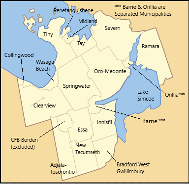
English: Map of Simcoe County, Ontario, with its component municipalities indicated. Based on File:Simcoe County Locator map.svg by User:Wikada which has been released to the Public Domain, with my own work added. |
| Date | |
| Source | Own work |
| Author | PKT |
Licensing
edit
I, the copyright holder of this work, hereby publish it under the following license:
This file is licensed under the Creative Commons Attribution-Share Alike 4.0 International license.
- You are free:
- to share – to copy, distribute and transmit the work
- to remix – to adapt the work
- Under the following conditions:
- attribution – You must give appropriate credit, provide a link to the license, and indicate if changes were made. You may do so in any reasonable manner, but not in any way that suggests the licensor endorses you or your use.
- share alike – If you remix, transform, or build upon the material, you must distribute your contributions under the same or compatible license as the original.
File history
Click on a date/time to view the file as it appeared at that time.
| Date/Time | Thumbnail | Dimensions | User | Comment | |
|---|---|---|---|---|---|
| current | 21:43, 25 October 2018 | | 384 × 375 (48 KB) | PKT (talk | contribs) | Label correction: "Clearwater" changed to "Clearview". |
| 22:37, 24 October 2018 |  | 384 × 375 (47 KB) | PKT (talk | contribs) | Corrected duplicated appearance of name "Innisfil" | |
| 22:22, 24 October 2018 |  | 384 × 375 (47 KB) | PKT (talk | contribs) | User created page with UploadWizard |
You cannot overwrite this file.
File usage on Commons
There are no pages that use this file.
File usage on other wikis
The following other wikis use this file:
- Usage on de.wikipedia.org
- Usage on en.wikipedia.org
- Usage on www.wikidata.org