File:Sineck Situations-Plan von Berlin 1889 (Humboldthafen u Panke).jpg

Size of this preview: 654 × 600 pixels. Other resolutions: 262 × 240 pixels | 523 × 480 pixels | 838 × 768 pixels | 1,117 × 1,024 pixels | 2,233 × 2,048 pixels | 3,120 × 2,861 pixels.
Original file (3,120 × 2,861 pixels, file size: 4.01 MB, MIME type: image/jpeg)
Captions
Captions
Add a one-line explanation of what this file represents
Summary
edit| Title |
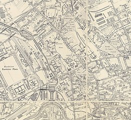
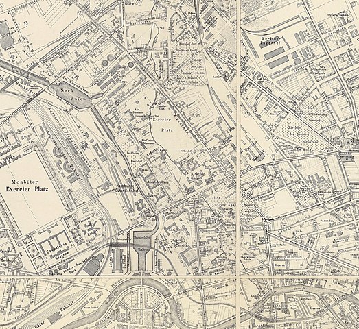
Situations-Plan von Berlin mit dem Weichbilde und Charlottenburg neu aufgenommen und gezeichnet von Sineck |
|||||||||
| Description |
Deutsch: Unter dem Plan steht: "Neu vollständig berichtigte Ausgabe von 1889". Es sind im Gegensatz zu weiteren Pländen derselben Serie keine Planungen in Rot eingetragen. Die erste Ausgabe dieser Planserie erschien 1866. |
|||||||||
| Date | ||||||||||
| Source | Bibliothèque nationale de France - Gallica (btv1b530249961) | |||||||||
| Creator |
Sineck, T. |
|||||||||
| Geotemporal data | ||||||||||
| Map location | Berlin | |||||||||
| Scale | 1:10,000 | |||||||||
| Heading |
 |
|||||||||
| Bounding box |
|
|||||||||
| Georeferencing | If inappropriate please set warp_status = skip to hide. | |||||||||
| Bibliographic data | ||||||||||
| Language | German | |||||||||
| Archival data | ||||||||||
| Collection | Bibliothèque nationale de France - Gallica | |||||||||
| Accession number |
btv1b530249961 |
|||||||||
| Dimensions | height: 101.5 cm (39.9 in); width: 136 cm (53.5 in) (height: 96.5 cm (37.9 in); width: 132 cm (51.9 in) map size) | |||||||||
| Medium | lithograph | |||||||||
| Notes |
Literatur
|
|||||||||
| Other versions |
|
|||||||||


.jpg&action=edit§ion=1)
Licensing
edit.jpg&action=edit§ion=2)
|
This is a faithful photographic reproduction of a two-dimensional, public domain work of art. The work of art itself is in the public domain for the following reason:
The official position taken by the Wikimedia Foundation is that "faithful reproductions of two-dimensional public domain works of art are public domain".
This photographic reproduction is therefore also considered to be in the public domain in the United States. In other jurisdictions, re-use of this content may be restricted; see Reuse of PD-Art photographs for details. | ||||
File history
Click on a date/time to view the file as it appeared at that time.
| Date/Time | Thumbnail | Dimensions | User | Comment | |
|---|---|---|---|---|---|
| current | 23:00, 10 January 2020 | | 3,120 × 2,861 (4.01 MB) | Boonekamp (talk | contribs) | File:Sineck Situations-Plan von Berlin 1889.jpg cropped 80 % horizontally, 74 % vertically using CropTool with precise mode. |
You cannot overwrite this file.
File usage on Commons
The following page uses this file:
File usage on other wikis
The following other wikis use this file:
- Usage on de.wikipedia.org
.jpg&oldid=699390636)