File:Site of a landslide near Abertysswg - geograph.org.uk - 955781.jpg
No higher resolution available.
Site_of_a_landslide_near_Abertysswg_-_geograph.org.uk_-_955781.jpg (640 × 480 pixels, file size: 145 KB, MIME type: image/jpeg)
Captions
Captions
Add a one-line explanation of what this file represents
Summary
edit
| Description |
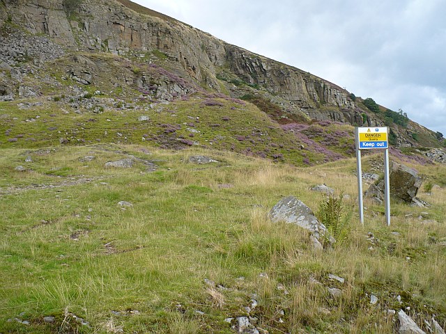
English: Site of a landslide near Abertysswg. The 1:25,000 OS map shows this as a quarry as does this warning sign. This however appears not to be the case. To quote from 'A Portrait of Rhymney, Vol 4' by Marion Evans, "Below Abertysswg coal production had been taking place at the Elliot Pits from as early as 1860, but the restlessness of the steep hillside towering above, the Moving Mountain, brought great unease to those within its vicinity. The mountain had moved five times since 1903 sending thousands of tons of rock to the valley floor below but it was in April 1930 that the greatest damage was done. It was then, on the twelfth of the month, that a vast avalanche of rock fell from the face of the mountain, overwhelming and ruining the offices and buildings of the New Tredegar Colliery. A further avalanche followed smashing the main road from Abertysswg to New Tredegar and demolishing the railway line thereby completely cutting off communication from Abertysswg to Bedwellty. The colliery was never used again and the road and railway never reconstructed despite many appeals for a road link to be re-opened."
For a map of the area before the landslide see http://www.npemap.org.uk/tiles/map.html#313,204,1 . For a view from the opposite side of the Rhymney Valley see 578902. |
| Date | |
| Source | From geograph.org.uk |
| Author | Robin Drayton |
| Attribution (required by the license) | Robin Drayton / Site of a landslide near Abertysswg / |
| Camera location | | View this and other nearby images on: OpenStreetMap |
|---|
_heading:112.00&language=en)
| Object location | | View this and other nearby images on: OpenStreetMap |
|---|
_heading:112.00&language=en)
Licensing
edit

|
This image was taken from the Geograph project collection. See this photograph's page on the Geograph website for the photographer's contact details. The copyright on this image is owned by Robin Drayton and is licensed for reuse under the Creative Commons Attribution-ShareAlike 2.0 license.
|
This file is licensed under the Creative Commons Attribution-Share Alike 2.0 Generic license.
Attribution: Robin Drayton
- You are free:
- to share – to copy, distribute and transmit the work
- to remix – to adapt the work
- Under the following conditions:
- attribution – You must give appropriate credit, provide a link to the license, and indicate if changes were made. You may do so in any reasonable manner, but not in any way that suggests the licensor endorses you or your use.
- share alike – If you remix, transform, or build upon the material, you must distribute your contributions under the same or compatible license as the original.
File history
Click on a date/time to view the file as it appeared at that time.
| Date/Time | Thumbnail | Dimensions | User | Comment | |
|---|---|---|---|---|---|
| current | 14:20, 22 February 2011 | | 640 × 480 (145 KB) | GeographBot (talk | contribs) | == {{int:filedesc}} == {{Information |description={{en|1=Site of a landslide near Abertysswg The 1:25,000 OS map shows this as a quarry as does this warning sign. This however appears not to be the case. To quote from 'A Portrait of Rhymney, Vol 4' by Mar |
You cannot overwrite this file.
File usage on Commons
There are no pages that use this file.