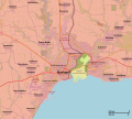
File:Situation in Mariupol.svg

Original file (SVG file, nominally 1,153 × 1,031 pixels, file size: 6.32 MB)
Captions
Captions
Summary edit
| DescriptionSituation in Mariupol.svg |
|
| Date | |
| Source |
Own work Control data from the Institute for the Study of War |
| Author | Rr016 |
Licensing edit
| DescriptionSituation in Mariupol.svg |
This map was created from OpenStreetMap project data, collected by the community. This map may be incomplete, and may contain errors. Don't rely solely on it for navigation. |
|||
| Date | (see file history) | |||
| Source | openstreetmap.org | |||
| Creator |
OpenStreetMap contributors |
|||
| Permission (Reusing this file) |
OpenStreetMap data is available under the Open Database License (details). Map tiles are licensed under the Creative Commons Attribution-ShareAlike 2.0 license (CC-BY-SA 2.0).
This file is licensed under the Creative Commons Attribution-Share Alike 2.0 Generic license.
|
|||
| Georeferencing | Georeference the map in Wikimaps Warper If inappropriate please set warp_status = skip to hide. |
- You are free:
- to share – to copy, distribute and transmit the work
- to remix – to adapt the work
- Under the following conditions:
- attribution – You must give appropriate credit, provide a link to the license, and indicate if changes were made. You may do so in any reasonable manner, but not in any way that suggests the licensor endorses you or your use.
- share alike – If you remix, transform, or build upon the material, you must distribute your contributions under the same or compatible license as the original.
| Annotations InfoField | This image is annotated: View the annotations at Commons |
According to the "southern front" and a number of other sources, the territory of the port and the Primorsky district is completely controlled by Russia
File history
Click on a date/time to view the file as it appeared at that time.
| Date/Time | Thumbnail | Dimensions | User | Comment | |
|---|---|---|---|---|---|
| current | 21:34, 18 May 2022 |  | 1,153 × 1,031 (6.32 MB) | Serafart (talk | contribs) | current situation in mariupol. to reference pre full DPR control see File:Situation in Mariupol 16 MAY 2022.svg |
| 21:04, 28 April 2022 |  | 1,153 × 1,031 (6.33 MB) | Rr016 (talk | contribs) | Update 2022-4-28: Azovstal northern cement factory under Russian control | |
| 07:25, 23 April 2022 |  | 1,153 × 1,031 (6.35 MB) | Borysk5 (talk | contribs) | https://www.understandingwar.org/backgrounder/russian-offensive-campaign-assessment-april-22 | |
| 13:43, 19 April 2022 |  | 1,153 × 1,031 (6.35 MB) | Borysk5 (talk | contribs) | Based on 18 APril IFSW article: https://www.understandingwar.org/backgrounder/russian-offensive-campaign-assessment-april-18 | |
| 13:29, 19 April 2022 |  | 640 × 480 (3.75 MB) | JanPawel2025 (talk | contribs) | udpate The Ukrainian Armed Forces only maintain the Azovstal factory | |
| 18:32, 17 April 2022 |  | 1,153 × 1,031 (6.36 MB) | Rr016 (talk | contribs) | Update 2022-4-17: Russian advances in Prymorskyi district, capturing a police station | |
| 08:02, 16 April 2022 |  | 1,153 × 1,031 (6.35 MB) | Borysk5 (talk | contribs) | Northern part of Mariupol has fallen: https://www.understandingwar.org/backgrounder/russian-offensive-campaign-assessment-april-15 | |
| 22:19, 13 April 2022 |  | 1,153 × 1,031 (6.37 MB) | Rr016 (talk | contribs) | Update 2022-4-13: Russian advances in Kalmiuskyi district, Ukrainian forces attempted breakout at Ilyich metal plant (northern pocket) | |
| 21:39, 11 April 2022 |  | 1,153 × 1,031 (6.36 MB) | Rr016 (talk | contribs) | Update 2022-4-11: Russian forces captured Mariupol fishing port (Tsentralnyi) separating Ukraine forces into two pockets, corrections to frontlines, | |
| 21:24, 8 April 2022 |  | 1,153 × 1,031 (6.36 MB) | Rr016 (talk | contribs) | Update 2022-4-8: Russians have captured the southern part of Mariupol port (Prymorskyi), reached the central bridge (Tsentralnyi), and advances in Livoberezhnyi |
You cannot overwrite this file.
File usage on Commons
The following 13 pages use this file:
- User:Jcornelius/Angola/2022 April 1-10
- User:Jcornelius/Angola/2022 April 11-20
- User:Jcornelius/Angola/2022 April 21-30
- User:Jcornelius/Angola/2022 March 1-10/Overflow 1
- User:Jcornelius/Angola/2022 March 11-20
- User:Jcornelius/Angola/2022 March 21-31
- User:Jcornelius/Angola/2022 May 11-20
- User:Magog the Ogre/Maps of conflicts/2022 April
- User:Magog the Ogre/Maps of conflicts/2022 March
- User:Magog the Ogre/Maps of conflicts/2022 May
- User:Rr016
- Category:Battle of Mariupol
- Category:Mariupol massacre
File usage on other wikis
The following other wikis use this file:
- Usage on az.wikipedia.org
- Usage on cs.wikipedia.org
- Usage on el.wikipedia.org
- Usage on fr.wikipedia.org
- Usage on it.wikipedia.org
- Usage on ka.wikipedia.org
- Usage on lv.wikipedia.org
- Usage on ms.wikipedia.org
- Usage on nl.wikipedia.org
- Usage on pl.wikipedia.org
- Usage on pt.wikipedia.org
- Usage on www.wikidata.org
Metadata
This file contains additional information such as Exif metadata which may have been added by the digital camera, scanner, or software program used to create or digitize it. If the file has been modified from its original state, some details such as the timestamp may not fully reflect those of the original file. The timestamp is only as accurate as the clock in the camera, and it may be completely wrong.
| Width | 922pt |
|---|---|
| Height | 825pt |
