File:Skagen Denmark Storm in October-2006.jpg

Size of this preview: 800 × 451 pixels. Other resolutions: 320 × 181 pixels | 640 × 361 pixels | 1,024 × 578 pixels | 1,280 × 722 pixels | 2,424 × 1,368 pixels.
Original file (2,424 × 1,368 pixels, file size: 3.38 MB, MIME type: image/jpeg)
Captions
Captions
Add a one-line explanation of what this file represents
Summary
edit
| Description |
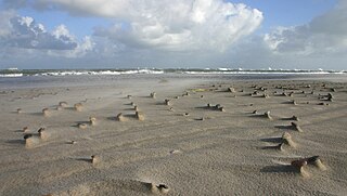
English: The picture is taken at Skagen peninsula, the most northern part of Denmark.It was taken during a storm with windspeeds at 20-26 meters pr. second. See Beaufort scale for comparision with other units. Flying sand and erosion of the landscape is clearly visible.External link with weather data for october 2006.[1]
Dansk: Billedet er taget på Grenen ved Skagen under en storm, med vindstyrker på 20-26 meter i sekundet.Der ses tydeligt flyvende sand, med efterfølgende erosion til følge. Ekstern link til vejr data for oktober 2006.[2] |
| Date | Published 2010-03-25 |
| Source | Own work |
| Author | S.Juhl |
Licensing
edit
| I, the copyright holder of this work, release this work into the public domain. This applies worldwide. In some countries this may not be legally possible; if so: I grant anyone the right to use this work for any purpose, without any conditions, unless such conditions are required by law. |
File history
Click on a date/time to view the file as it appeared at that time.
| Date/Time | Thumbnail | Dimensions | User | Comment | |
|---|---|---|---|---|---|
| current | 14:30, 25 March 2010 | | 2,424 × 1,368 (3.38 MB) | S.Juhl (talk | contribs) | {{Information |Description={{en|1=The picture is taken at [http://en.wikipedia.org/wiki/Skagen|Skagen]] peninsula, the most northern part of [http://en.wikipedia.org/wiki/Denmark|Denmark]].It was taken during a storm with windspeeds at 20-26 met |
You cannot overwrite this file.
File usage on Commons
There are no pages that use this file.
File usage on other wikis
The following other wikis use this file:
- Usage on da.wikipedia.org
- Usage on da.wikibooks.org
- Usage on no.wikipedia.org