File:Sketch Map of a Portion of Jubaland from Sketches of Officers and Travellers. (WOMAT-AFR-BEA-91).jpg

Size of this preview: 425 × 599 pixels. Other resolutions: 170 × 240 pixels | 340 × 480 pixels | 544 × 768 pixels | 726 × 1,024 pixels | 1,452 × 2,048 pixels | 6,237 × 8,797 pixels.
Original file (6,237 × 8,797 pixels, file size: 34.11 MB, MIME type: image/jpeg)
Captions
Captions
Add a one-line explanation of what this file represents
Summary
edit| Title |
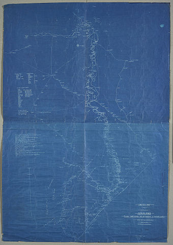
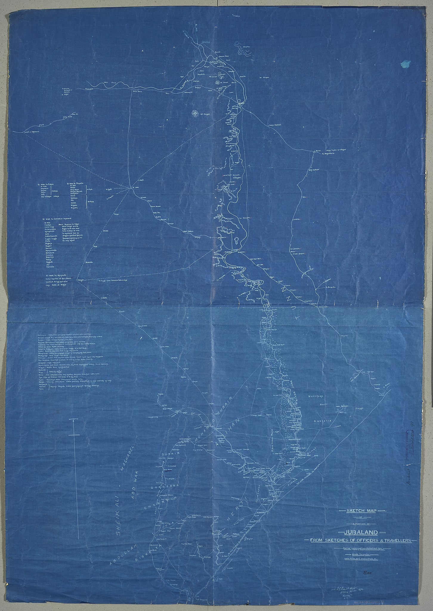
'Sketch Map of a Portion of Jubaland from Sketches of Officers and Travellers'.'(sd:) R.E. Salkeld Capt. 3rd. King's Africa Rifles Kismayu 5.12.02' |
|||||||||
| Description |
Shows a region in East Africa, indicating roads, settlements, some relief with form lines, tribal regions, vegetation and hydrology, with descriptions of topography. Also provides a list of locations and descriptions of water availablility, and a list of stages and journey times to points west. |
|||||||||
| British Library Shelfmark | WOMAT/AFR/BEA/91 | |||||||||
| Locations Depicted | Jubaland, Somalia | |||||||||
| Centre Point Coordinates | 1.7081,41.9021 | |||||||||
| Date | ||||||||||
| Source |
|
|||||||||
| Creator |
Salkeld, Robert Edward, 1867-1927, army officer, Author |
|||||||||
| Permission (Reusing this file) |
|
|||||||||
| Geotemporal data | ||||||||||
| Map location | British East Africa | |||||||||
| Scale | 1:506,880 | |||||||||
| Bounding box |
|
|||||||||
| Georeferencing | If inappropriate please set warp_status = skip to hide. | |||||||||
| Archival data | ||||||||||
| Collection | ||||||||||
| Dimensions | 135 x 94cm | |||||||||
| Medium | Blueprint with manuscript additions | |||||||||
| Notes | For more information please see the British Library’s Collection Guide to the War Office Archive. | |||||||||

_(St_Edwards_Crown).svg)


.jpg&action=edit§ion=1)
.jpg¶ms=4.6656_N_39.8800_E_)
.jpg¶ms=4.6656_N_43.9242_E_)
.jpg¶ms=-1.2494_N_39.8800_E_)
.jpg¶ms=-1.2494_N_43.9242_E_)
File history
Click on a date/time to view the file as it appeared at that time.
| Date/Time | Thumbnail | Dimensions | User | Comment | |
|---|---|---|---|---|---|
| current | 18:37, 23 November 2015 | | 6,237 × 8,797 (34.11 MB) | Ndalyrose (talk | contribs) | GWToolset: Creating mediafile for Ndalyrose. |
You cannot overwrite this file.
File usage on Commons
There are no pages that use this file.
.jpg&oldid=479515865)