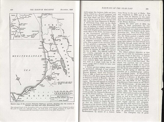
File:Sketch map of the present Palestine railways system, showing also the course of various war - time and other dismantled lines (FL45584619 3927463).jpg

Size of this preview: 800 × 595 pixels. Other resolutions: 320 × 238 pixels | 640 × 476 pixels | 1,024 × 761 pixels | 1,280 × 952 pixels | 2,560 × 1,903 pixels | 3,852 × 2,864 pixels.
Original file (3,852 × 2,864 pixels, file size: 2.02 MB, MIME type: image/jpeg)
Captions
Captions
Add a one-line explanation of what this file represents
Summary
edit| Sketch map of the present Palestine railways system, showing also the course of various war - time and other dismantled lines
( |
||||||||||||||||||||||||
|---|---|---|---|---|---|---|---|---|---|---|---|---|---|---|---|---|---|---|---|---|---|---|---|---|
| Title |
Sketch map of the present Palestine railways system, showing also the course of various war - time and other dismantled lines |
|||||||||||||||||||||||
| Publisher |
The Railway Magazine |
|||||||||||||||||||||||
| Description |
Sketch map of the present Palestine railways system, showing also the course of various war - time and other dismantled lines.. |
|||||||||||||||||||||||
| Language | English | |||||||||||||||||||||||
| Publication date | 1936 | |||||||||||||||||||||||
| Medium | 1 online resource (1 map). | |||||||||||||||||||||||
| Collection |
|
|||||||||||||||||||||||
| Current location |
|
|||||||||||||||||||||||
| Place of publication | London | |||||||||||||||||||||||
| search Merhav catalog | London | |||||||||||||||||||||||
| Notes | Digital image of the original in Amir Cahanovitc Collection, Israel. ACC 2818.; Digital image received from donor.; From: Railway Magazine, December 1936. | |||||||||||||||||||||||
| IE PID | IE45584617 | |||||||||||||||||||||||
| Rosetta filename | FL45584619 | |||||||||||||||||||||||
| NNL item ID (P3959) | 990039274630205171 | |||||||||||||||||||||||
| search Merhav catalog | English | |||||||||||||||||||||||
| search Merhav catalog | RailroadsEretz IsraelMapsThe Railway Magazine | |||||||||||||||||||||||
| Source/Photographer |
|
|||||||||||||||||||||||
| Other versions | ||||||||||||||||||||||||
| Jpg / Tif version |
|
|||||||||||||||||||||||

.jpg)

.jpg&action=edit§ion=1)
Licensing
edit.jpg&action=edit§ion=2)
This work created by the United Kingdom Government is in the public domain.
This is because it is one of the following:
HMSO has declared that the expiry of Crown Copyrights applies worldwide (ref: HMSO Email Reply)
|
 |
File history
Click on a date/time to view the file as it appeared at that time.
| Date/Time | Thumbnail | Dimensions | User | Comment | |
|---|---|---|---|---|---|
| current | 21:49, 10 August 2023 | | 3,852 × 2,864 (2.02 MB) | Geagea (talk | contribs) | pattypan 22.03 |
You cannot overwrite this file.
File usage on Commons
The following 2 pages use this file:
.jpg&oldid=792424755)