File:Skoki (gmina) location map.png

Size of this preview: 634 × 600 pixels. Other resolutions: 254 × 240 pixels | 507 × 480 pixels | 948 × 897 pixels.
Original file (948 × 897 pixels, file size: 145 KB, MIME type: image/png)
Captions
Captions
Add a one-line explanation of what this file represents
| Description |
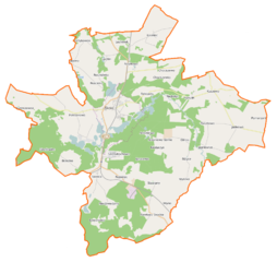
Polski: Mapa gminy Skoki, Polska
English: Map of Gmina Skoki, Poland |
|||||||||
| Date | ||||||||||
| Source | You may find a page on the OpenStreetMap wiki page for Skoki (gmina) | |||||||||
| Creator |
OpenStreetMap contributors OpenStreetMap contributors |
|||||||||
| Permission (Reusing this file) |
OpenStreetMap data is available under the Open Database License (details). Map tiles are licensed under the Creative Commons Attribution-ShareAlike 2.0 license (CC-BY-SA 2.0).
This file is licensed under the Creative Commons Attribution-Share Alike 2.0 Generic license.
|
|||||||||
| Geotemporal data | ||||||||||
| Bounding box |
|
|||||||||
| Georeferencing | If inappropriate please set warp_status = skip to hide. | |||||||||
File history
Click on a date/time to view the file as it appeared at that time.
| Date/Time | Thumbnail | Dimensions | User | Comment | |
|---|---|---|---|---|---|
| current | 23:07, 3 January 2015 | | 948 × 897 (145 KB) | VanWiel (talk | contribs) | {{OpenStreetMap | name = Skoki (gmina) | location = Skoki (gmina) | description = {{pl|Mapa gminy Skoki, Polska}} {{en|Map of Gmina Skoki, Poland}} | top = 52.7494 | bottom = 52.5624 | left... |
You cannot overwrite this file.
File usage on Commons
There are no pages that use this file.
File usage on other wikis
The following other wikis use this file:
- Usage on de.wikipedia.org
- Usage on fr.wikipedia.org
- Usage on nl.wikipedia.org
- Usage on pl.wikipedia.org
- Skoki (gmina)
- Jabłkowo
- Kuszewo (województwo wielkopolskie)
- Kakulin
- Lechlin
- Niedźwiedziny
- Pawłowo Skockie
- Pomarzanki (powiat wągrowiecki)
- Potrzanowo
- Raczkowo
- Rościnno
- Rakojady (województwo wielkopolskie)
- Bliżyce (województwo wielkopolskie)
- Budziszewice (województwo wielkopolskie)
- Chociszewo (województwo wielkopolskie)
- Łosiniec (województwo wielkopolskie)
- Rejowiec (województwo wielkopolskie)
- Sławica (województwo wielkopolskie)
- Brzeźno (powiat wągrowiecki)
- Glinno (powiat wągrowiecki)
- Grzybowo (powiat wągrowiecki)
- Roszkowo (powiat wągrowiecki)
- Szczodrochowo (powiat wągrowiecki)
- Wysoka (powiat wągrowiecki)
- Skoki (miasto)
- Stawiany (województwo wielkopolskie)
- Jagniewice
- Sława Wielkopolska
- Grzybowice (województwo wielkopolskie)
- Antoniewo Górne
- Niedarzyn (Glinno)
- Dzwonowo (Niedźwiedziny)
- Dzwonowo Leśne
- Miączynek (Niedźwiedziny)
- Chociszewko
- Antoniewo (osada leśna w powiecie wągrowieckim)
- Nadmłyn
- Lechlińskie Huby
- Młynki (województwo wielkopolskie)
- Ignacewo (powiat wągrowiecki)
- Lechlinek
- Antoniewo (osada w powiecie wągrowieckim)
- Roszkówko (powiat wągrowiecki)
- Stawiany (stacja kolejowa)
- Sława Wielkopolska (stacja kolejowa)
- Skoki (przystanek kolejowy)
- Roszkowo Wągrowieckie
View more global usage of this file.
_location_map.png)
_location_map.png&oldid=480129345)