File:Skuteč, CZ161211-056.jpg
Original file (4,570 × 2,637 pixels, file size: 3.53 MB, MIME type: image/jpeg)
Captions
Summary
editDescriptionSkuteč, CZ161211-056.jpg |
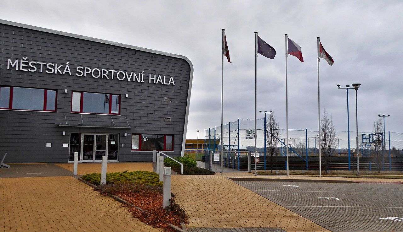
English: Municipal Sports Hall (part of the building) and the entrance to the campus football and athletic stadium. Photo location: Czechia, Pardubice Region, Skuteč town.
Čeština: Městská sportovní hala (část budovy) a vchod do areálu fotbalového a atletického stadionu. Foto lokace: Česko, Pardubický kraj, město Skuteč. |
Date | |
Source | Own work |
Author | Josef Kreuz (PEPan) |
Camera location | 49° 50′ 35.62″ N, 15° 59′ 35.91″ E | View this and other nearby images on: OpenStreetMap | 49.843228; 15.993307 |
---|
Faktografie: Městská sportovní hala ve Skutči byla slavnostně otevřena 10.9.2010, interiér multifunkčního sportovního objektu disponuje dvěma tělocvičnami (48x25 m a 15x15 m), jedním menším prostorem pro cvičení (10x5 m), sociálním zařízením a nezbytným technickým zázemím. Investiční akce si vyžádala 81 mil. Kč. Rozsáhlá a architektonicky originální budova stojí na místě původní sportovní haly z roku 1959 a k ní náležející později postavené ubytovny se saunou. Externí odkazy: * 2017-01-13 Město Skuteč ( http://www.skutec.cz/ ), * 2017-01-13 Skuteč - turistické informační centrum ( http://www.skutecsky.navstevnik.cz/sluzby/informacni-centrum/ ), * 2017-01-13 Skuteč a okolí - turistická mapa ( https://mapy.cz/s/1kmCB ).
Licensing
edit- You are free:
- to share – to copy, distribute and transmit the work
- to remix – to adapt the work
- Under the following conditions:
- attribution – You must give appropriate credit, provide a link to the license, and indicate if changes were made. You may do so in any reasonable manner, but not in any way that suggests the licensor endorses you or your use.
- share alike – If you remix, transform, or build upon the material, you must distribute your contributions under the same or compatible license as the original.
File history
Click on a date/time to view the file as it appeared at that time.
Date/Time | Thumbnail | Dimensions | User | Comment | |
---|---|---|---|---|---|
current | 12:55, 15 January 2017 | 4,570 × 2,637 (3.53 MB) | PEPan (talk | contribs) | User created page with UploadWizard |
You cannot overwrite this file.
File usage on Commons
There are no pages that use this file.
File usage on other wikis
The following other wikis use this file:
- Usage on cs.wikipedia.org
Metadata
This file contains additional information such as Exif metadata which may have been added by the digital camera, scanner, or software program used to create or digitize it. If the file has been modified from its original state, some details such as the timestamp may not fully reflect those of the original file. The timestamp is only as accurate as the clock in the camera, and it may be completely wrong.
Camera manufacturer | Panasonic |
---|---|
Camera model | DMC-TZ60 |
Author | Josef Kreuz |
Copyright holder |
|
Exposure time | 1/60 sec (0.016666666666667) |
F-number | f/3.5 |
ISO speed rating | 100 |
Date and time of data generation | 11:47, 11 December 2016 |
Lens focal length | 5 mm |
User comments | EN: Municipal Sports Hall (part of the building) and the entrance to the campus football and athletic stadium. Photo location: Czechia, Pardubice Region, Skuteč town. CZ: Městská sportovní hala (část budovy) a vchod do areálu fotbalového a atletického stadionu. Foto lokace: Česko, Pardubický kraj, město Skuteč. Faktografie: Městská sportovní hala ve Skutči byla slavnostně otevřena 10.9.2010, interiér multifunkčního sportovního objektu disponuje dvěma tělocvičnami (48x25 m a 15x15 m), jedním menším prostorem pro cvičení (10x5 m), sociálním zařízením a nezbytným technickým zázemím. Investiční akce si vyžádala 81 mil. Kč. Rozsáhlá a architektonicky originální budova stojí na místě původní sportovní haly z roku 1959 a k ní náležející později postavené ubytovny se saunou. Externí odkazy: * 2017-01-13 Město Skuteč ( http://www.skutec.cz/ ), * 2017-01-13 Skuteč - turistické informační centrum ( http://www.skutecsky.navstevnik.cz/sluzby/informacni-centrum/ ), * 2017-01-13 Skuteč a okolí - turistická mapa ( https://mapy.cz/s/1kmCB ). |
Latitude | 49° 50′ 35.62″ N |
Longitude | 15° 59′ 35.91″ E |
Short title |
|
Image title |
|
Label | Orange |
City shown | Skuteč |
Compression scheme | Uncompressed |
Pixel composition | RGB |
Orientation | Normal |
Horizontal resolution | 180 dpi |
Vertical resolution | 180 dpi |
Data arrangement | chunky format |
Software used | Zoner Photo Studio 18 |
File change date and time | 13:53, 15 January 2017 |
Y and C positioning | Centered |
Exposure Program | Normal program |
Exif version | 2.3 |
Date and time of digitizing | 11:47, 11 December 2016 |
Meaning of each component |
|
Image compression mode | 4 |
APEX exposure bias | 0 |
Maximum land aperture | 3.6171875 APEX (f/3.5) |
Metering mode | Pattern |
Light source | Unknown |
Flash | Flash did not fire, compulsory flash suppression |
Supported Flashpix version | 1 |
Color space | sRGB |
Sensing method | One-chip color area sensor |
File source | Digital still camera |
Scene type | A directly photographed image |
Custom image processing | Normal process |
Exposure mode | Auto exposure |
White balance | Auto white balance |
Digital zoom ratio | 0 |
Focal length in 35 mm film | 32 mm |
Scene capture type | Standard |
Scene control | None |
Contrast | Normal |
Saturation | Normal |
Sharpness | Normal |
GPS time (atomic clock) | 09:43 |
Receiver status | Measurement in progress |
Measurement mode | 2-dimensional measurement |
Measurement precision | Fair (1.1) |
Geodetic survey data used | WGS-84 |
Name of GPS area | 匀欀甀琀攀ഁ |
GPS date | 11 December 2016 |
GPS tag version | 0.0.3.2 |
Writer | Josef Kreuz |
Country shown | Česko |
Province or state shown | Pardubický kraj |
Code for country shown | CZ |
Sublocation of city shown | ulice Československé armády |