File:Skutečská pahorkatina - Ochoz, CZ160807.jpg
Size of this preview: 800 × 556 pixels. Other resolutions: 320 × 222 pixels | 640 × 444 pixels | 1,024 × 711 pixels | 1,280 × 889 pixels | 2,560 × 1,778 pixels | 4,860 × 3,375 pixels.
Original file (4,860 × 3,375 pixels, file size: 5.74 MB, MIME type: image/jpeg)
File information
Structured data
Captions
Summary edit
DescriptionSkutečská pahorkatina - Ochoz, CZ160807.jpg |
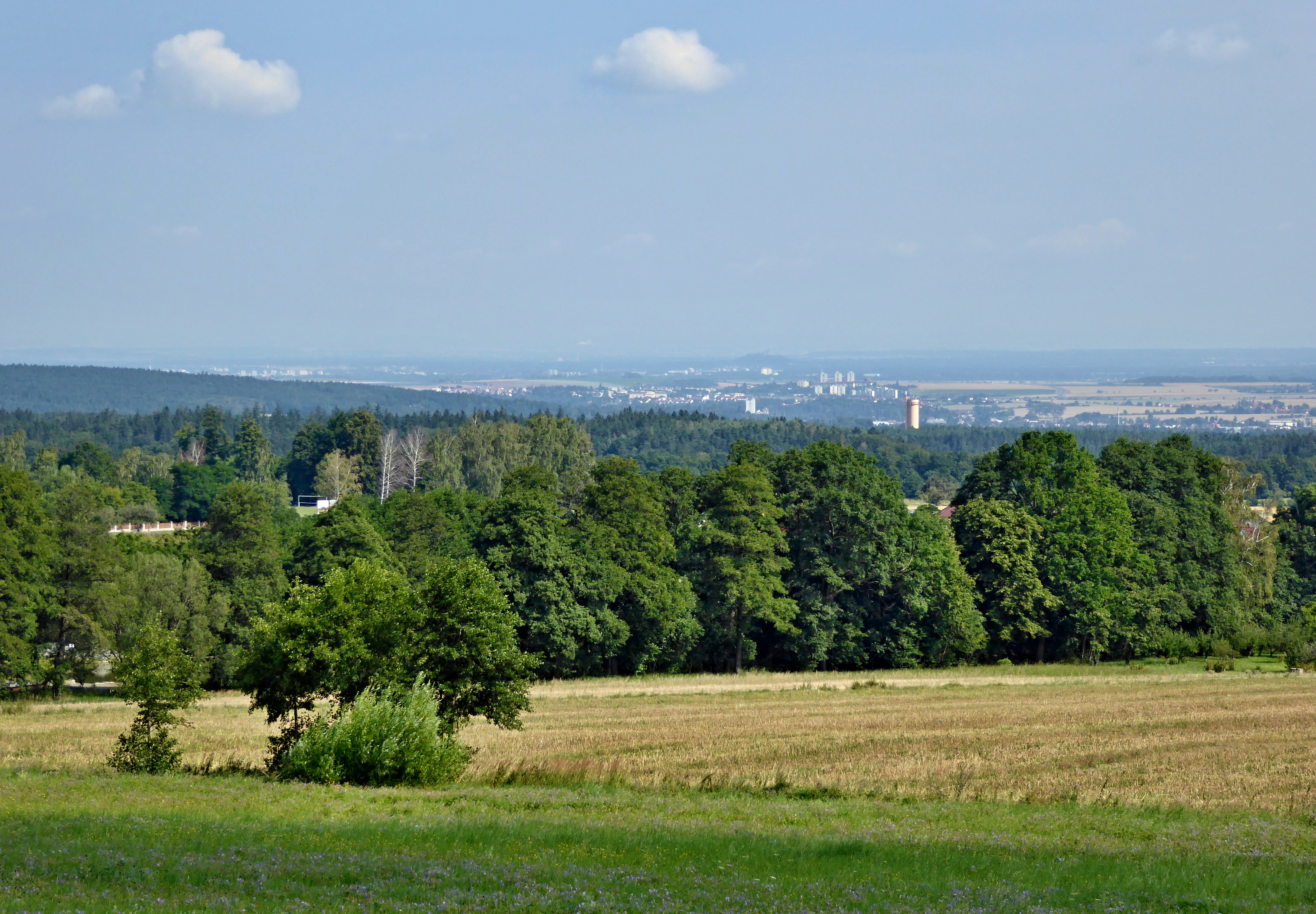
Čeština: Severní svahy vrcholové části Ochozu (520 m n.m.) nad stejnojmennou obcí u Nasavrk poskytují výhled do značné části Pardubického kraje severním a částečně až východním směrem. Dobře pozorovatelná je zejména oblast kolem Chrudimi a při dobré viditelnosti i Kunětická hora, také Krkonoše, Orlické hory a Králický Sněžník. V pravé části záběru viditelný vrchol vodárenské vyrovnávací věže Práčov. Z jižní strany vrchol Ochozu převyšuje postupně rekultivovaná halda komunálního odpadu, který se zde dlouhé roky ukládal na řízenou skládku z mnoha okolních obcí. Zeměpisná mapa (Mapy.cz) - viz https://mapy.cz/s/Y7G7 (pohled - azimut 0°). |
Date | |
Source | Own work |
Author | Josef Kreuz (PEPan) |
Camera location | 49° 50′ 33.83″ N, 15° 48′ 39.55″ E | View this and other nearby images on: OpenStreetMap | 49.842731; 15.810986 |
---|
Zeměpisná mapa (Mapy.cz) - viz https://mapy.cz/s/Y7G7 (pohled - azimut 0°).
Licensing edit
I, the copyright holder of this work, hereby publish it under the following license:
This file is licensed under the Creative Commons Attribution-Share Alike 4.0 International license.
- You are free:
- to share – to copy, distribute and transmit the work
- to remix – to adapt the work
- Under the following conditions:
- attribution – You must give appropriate credit, provide a link to the license, and indicate if changes were made. You may do so in any reasonable manner, but not in any way that suggests the licensor endorses you or your use.
- share alike – If you remix, transform, or build upon the material, you must distribute your contributions under the same or compatible license as the original.
File history
Click on a date/time to view the file as it appeared at that time.
Date/Time | Thumbnail | Dimensions | User | Comment | |
---|---|---|---|---|---|
current | 10:44, 13 August 2016 | 4,860 × 3,375 (5.74 MB) | PEPan (talk | contribs) | User created page with UploadWizard |
You cannot overwrite this file.
File usage on Commons
There are no pages that use this file.
File usage on other wikis
The following other wikis use this file:
- Usage on cs.wikipedia.org
Metadata
This file contains additional information such as Exif metadata which may have been added by the digital camera, scanner, or software program used to create or digitize it. If the file has been modified from its original state, some details such as the timestamp may not fully reflect those of the original file. The timestamp is only as accurate as the clock in the camera, and it may be completely wrong.
Camera manufacturer | Panasonic |
---|---|
Camera model | DMC-TZ60 |
Author | Josef Kreuz |
Copyright holder |
|
Exposure time | 1/400 sec (0.0025) |
F-number | f/5.1 |
ISO speed rating | 100 |
Date and time of data generation | 10:12, 7 August 2016 |
Lens focal length | 19 mm |
User comments | Nasavrky, CZ160807 © Josef Kreuz : Severní svahy ve vrcholové části Ochozu (520 m n.m.) nad stejnojmennou obcí u Nasavrk poskytují výhled do značné části Pardubického kraje severním a částečně až východním směrem. Dobře pozorovatelná je zejména oblast kolem Chrudimi a při dobré viditelnosti i Kunětická hora, také však Krkonoše nebo Orlické hory a Králický Sněžník. V pravé části záběru viditelná vrcholová část vodárenské vyrovnávací věže Práčov. Z jižní strany vrchol převyšuje postupně rekultivovaná halda komunálního odpadu, který se zde dlouhé roky ukládal na řízenou skládku z mnoha okolních obcí. Zeměpisná mapa (Mapy.cz) - viz https://mapy.cz/s/Y7G7 (pohled - azimut 0°). |
Latitude | 49° 50′ 33.83″ N |
Longitude | 15° 48′ 39.55″ E |
Short title |
|
Image title |
|
Label | Red |
Compression scheme | Uncompressed |
Pixel composition | RGB |
Orientation | Normal |
Horizontal resolution | 180 dpi |
Vertical resolution | 180 dpi |
Data arrangement | chunky format |
Software used | Ver.1.0 |
File change date and time | 12:36, 13 August 2016 |
Y and C positioning | Centered |
Exposure Program | Landscape mode (for landscape photos with the background in focus) |
Exif version | 2.3 |
Date and time of digitizing | 10:12, 7 August 2016 |
Meaning of each component |
|
Image compression mode | 4 |
APEX exposure bias | 0 |
Maximum land aperture | 4.703125 APEX (f/5.1) |
Metering mode | Pattern |
Light source | Unknown |
Flash | Flash did not fire, compulsory flash suppression |
Supported Flashpix version | 1 |
Color space | sRGB |
Sensing method | One-chip color area sensor |
File source | Digital still camera |
Scene type | A directly photographed image |
Custom image processing | Normal process |
Exposure mode | Auto exposure |
White balance | Auto white balance |
Digital zoom ratio | 0 |
Focal length in 35 mm film | 117 mm |
Scene capture type | Standard |
Scene control | None |
Contrast | Normal |
Saturation | Normal |
Sharpness | Normal |
Unique image ID | A198209907724DD1BD630600B54DA7BA |
GPS time (atomic clock) | 08:11 |
Receiver status | Measurement in progress |
Measurement mode | 2-dimensional measurement |
Measurement precision | Fair (1.1) |
Geodetic survey data used | WGS-84 |
Name of GPS area | 一愀猀愀瘀爀欀礀 |
GPS date | 7 August 2016 |
GPS tag version | 0.0.3.2 |
Writer | Josef Kreuz |