File:Slant range.png
No higher resolution available.
Slant_range.png (405 × 255 pixels, file size: 1 KB, MIME type: image/png)
Captions
Captions
Add a one-line explanation of what this file represents
Summary edit
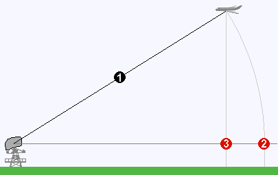
| Description | Slant range (1) is the line-of-sight distance between two points which are not at the same level relative to a specific datum. In the absence of altitude information, the location of an aircraft flying at high altitude would be plotted farther (2) from a RADAR antenna than its actual ground track (3), which follows a circular trace. |
| Date | |
| Source | en:Slant range |
| Author | WolfgangW., using pixel grafics from de:Bild:Radaroperation.gif by de:user:Averse |
Licensing edit
I, the copyright holder of this work, hereby publish it under the following licenses:

|
Permission is granted to copy, distribute and/or modify this document under the terms of the GNU Free Documentation License, Version 1.2 or any later version published by the Free Software Foundation; with no Invariant Sections, no Front-Cover Texts, and no Back-Cover Texts. A copy of the license is included in the section entitled GNU Free Documentation License. |
| This file is licensed under the Creative Commons Attribution-Share Alike 3.0 Unported license. | ||
| ||
| This licensing tag was added to this file as part of the GFDL licensing update. |
This file is licensed under the Creative Commons Attribution-Share Alike 2.5 Generic, 2.0 Generic and 1.0 Generic license.
- You are free:
- to share – to copy, distribute and transmit the work
- to remix – to adapt the work
- Under the following conditions:
- attribution – You must give appropriate credit, provide a link to the license, and indicate if changes were made. You may do so in any reasonable manner, but not in any way that suggests the licensor endorses you or your use.
- share alike – If you remix, transform, or build upon the material, you must distribute your contributions under the same or compatible license as the original.
You may select the license of your choice.
File history
Click on a date/time to view the file as it appeared at that time.
| Date/Time | Thumbnail | Dimensions | User | Comment | |
|---|---|---|---|---|---|
| current | 16:45, 30 March 2007 | | 405 × 255 (1 KB) | I.R. Annie IP. (talk | contribs) | {{Information |Description='''Slant range''' (1) is the line-of-sight distance between two points which are not at the same level relative to a specific datum. In the absence of altitude information, the location of an aircraft flying at high altitude wou |
You cannot overwrite this file.
File usage on Commons
There are no pages that use this file.
File usage on other wikis
The following other wikis use this file:
- Usage on en.wikipedia.org
- Usage on en.wiktionary.org
- Usage on zh.wiktionary.org