File:Slaven.jpg
Size of this preview: 700 × 599 pixels. Other resolutions: 280 × 240 pixels | 561 × 480 pixels | 897 × 768 pixels | 1,196 × 1,024 pixels | 2,392 × 2,048 pixels | 3,216 × 2,754 pixels.
Original file (3,216 × 2,754 pixels, file size: 5.22 MB, MIME type: image/jpeg)
Captions
Captions
Add a one-line explanation of what this file represents
Summary
edit
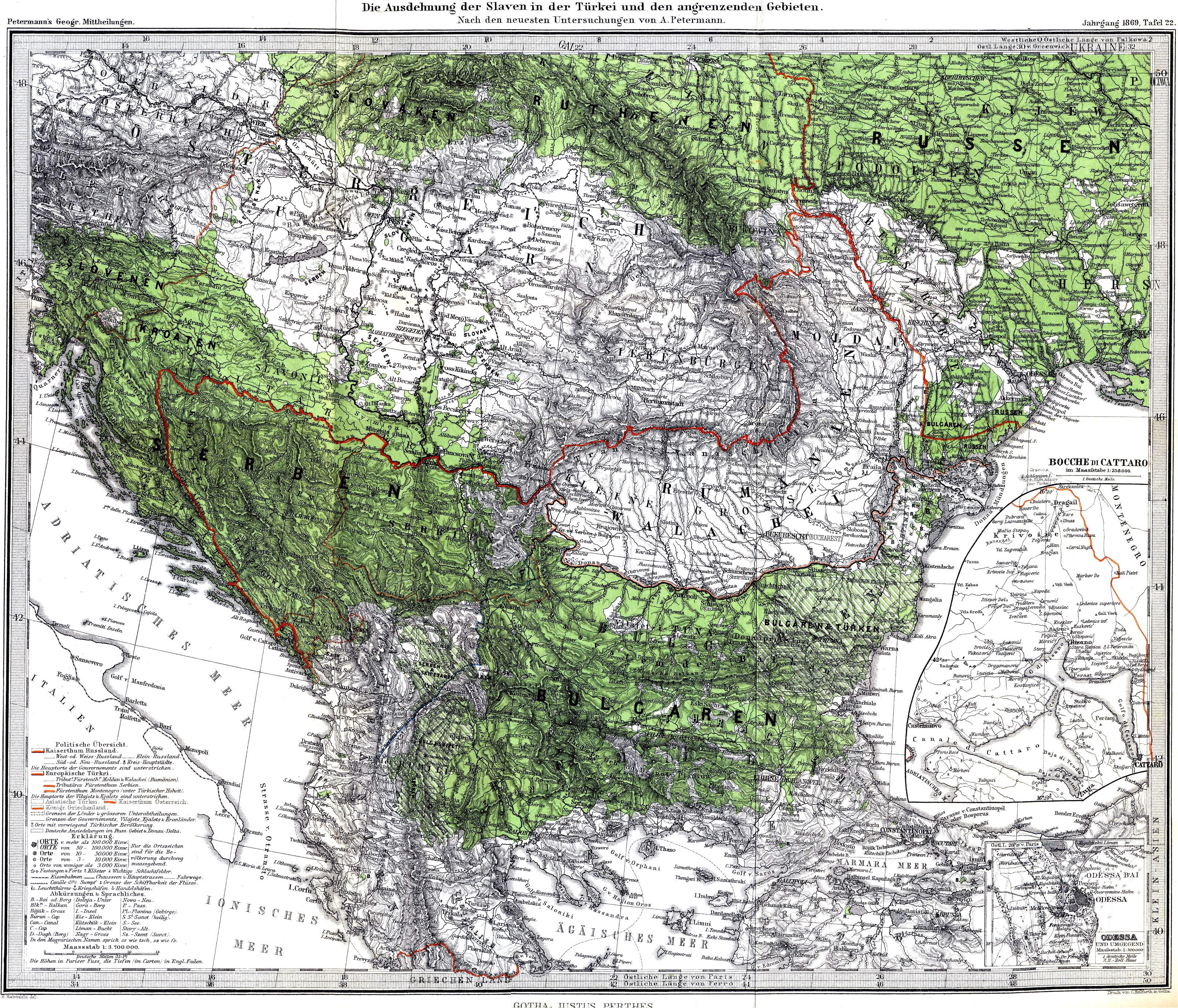
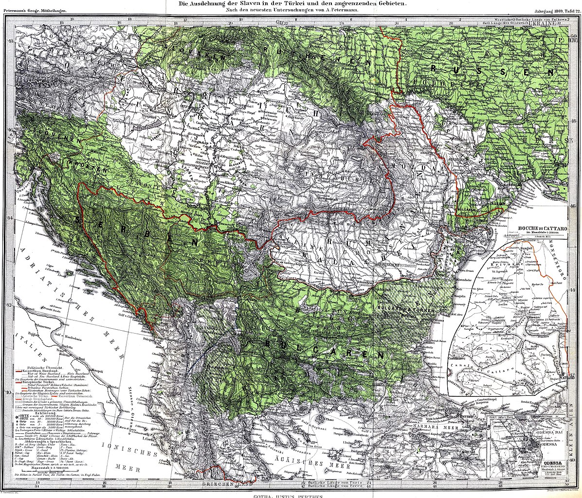
| Description | The Spread of Slavs in the Balkan Peninsula and the Carpathian-Danubian space, 1869. The author of this map was the renowned cartographer August Heinrich Petermann. According to Henry Robert Wilkinson (Maps and politics: a review of the ethnographic cartography of Macedonia, Liverpool, England : University Press, 1951, p. 55.) the author of the explanatory text to the map was the Croatian ethnographer prof. F. Bradashka. |
| Date | |
| Source | Petermanns Mitteilungen |
| Author | August Heinrich Petermann |
Licensing
edit
|
This work is in the public domain in its country of origin and other countries and areas where the copyright term is the author's life plus 70 years or fewer. | |
| This file has been identified as being free of known restrictions under copyright law, including all related and neighboring rights. | |
File history
Click on a date/time to view the file as it appeared at that time.
| Date/Time | Thumbnail | Dimensions | User | Comment | |
|---|---|---|---|---|---|
| current | 17:34, 5 September 2021 | | 3,216 × 2,754 (5.22 MB) | Claude Zygiel (talk | contribs) | Contrast & cosmetic |
| 21:53, 8 December 2009 |  | 3,216 × 2,754 (5.01 MB) | Alex:D (talk | contribs) | whitened | |
| 00:37, 6 May 2008 |  | 3,216 × 2,754 (5.1 MB) | Olahus (talk | contribs) | {{Information |Description=The Spread of Slavs in the Balkan Peninsula and the Carpathian-Danubian space. |Source=Petermanns Mitteilungen |Date=1869 |Author=own scan |Permission= |other_versions= }} Category:Maps in German [[Category:Lin |
You cannot overwrite this file.
File usage on Commons
The following 6 pages use this file:
File usage on other wikis
The following other wikis use this file:
- Usage on bg.wikipedia.org
- Usage on de.wikipedia.org
- Usage on en.wikipedia.org
- Usage on fr.wikipedia.org
- Usage on pl.wikipedia.org
- Usage on pt.wikipedia.org
- Usage on ro.wikipedia.org
- Usage on ru.wikipedia.org
- Usage on sq.wikipedia.org
- Usage on uk.wikipedia.org