File:Snow across the Midwestern United States (MODIS).jpg

Size of this preview: 800 × 540 pixels. Other resolutions: 320 × 216 pixels | 640 × 432 pixels | 1,024 × 691 pixels | 1,280 × 864 pixels | 2,560 × 1,729 pixels | 4,883 × 3,297 pixels.
Original file (4,883 × 3,297 pixels, file size: 2.1 MB, MIME type: image/jpeg)
Captions
Captions
Add a one-line explanation of what this file represents
Summary
edit.jpg&action=edit§ion=1)
| Description |
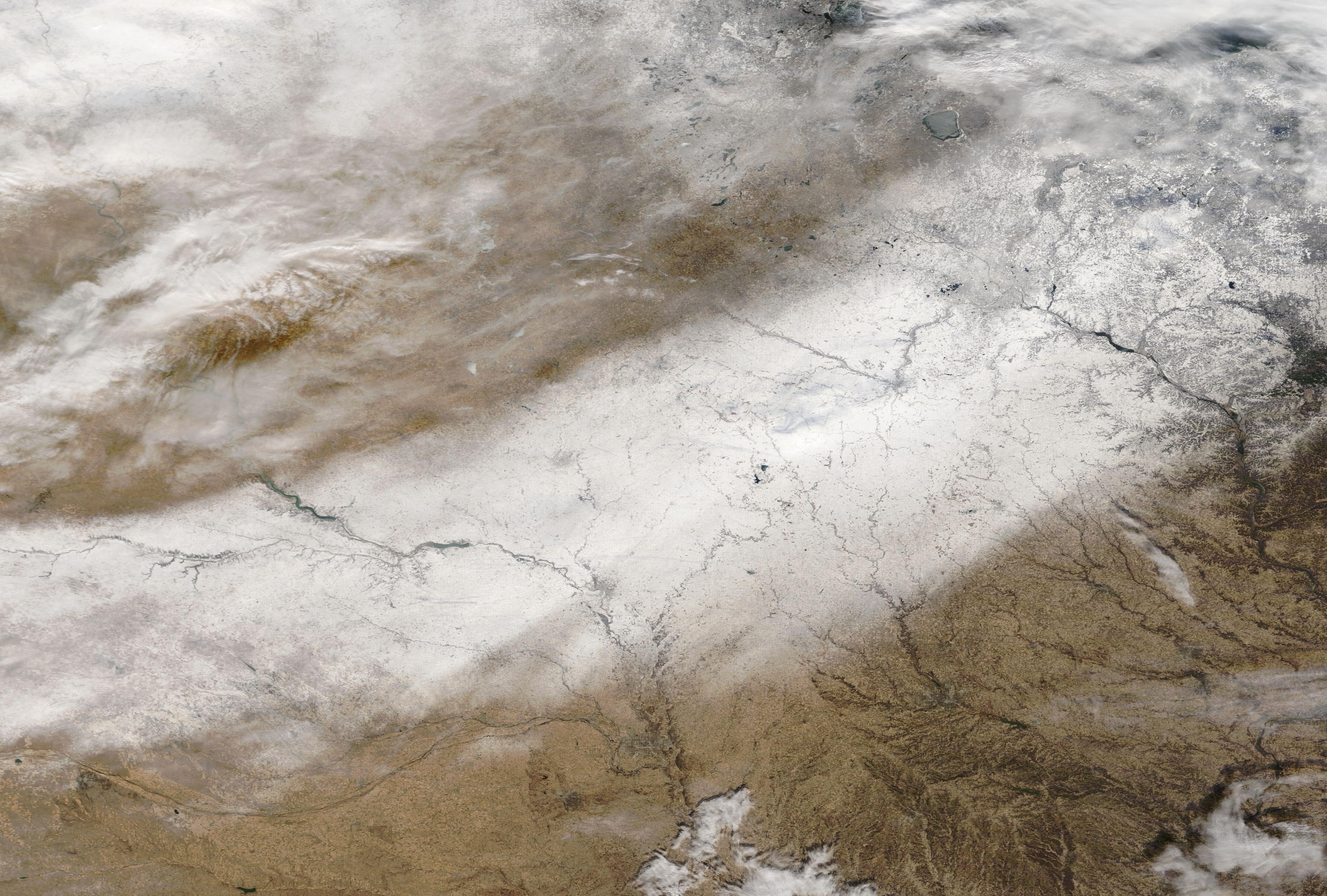
English: On the first day of meteorological winter, December 1, 2022, the Moderate Resolution Imaging Spectroradiometer (MODIS) on board NASA’s Terra satellite acquired a true-color image of a broad band of snow stretching across parts of the Midwestern United States. The snowy swath was dropped by a late-November snowstorm that crossed the Midwest on November 29, bringing snow, sleet, ice, and driving accidents to the region, including reports of a jack-knifed tractor trailer on icy Highway 275 near Norfolk, Nebraska. The states coated with the fresh swath of white in this image include (from southwest to northeast): Nebraska, southeast South Dakota, Iowa, Minnesota, and Wisconsin. In the northwest, cloud covers most of South Dakota and part of North Dakota.
When we think of the first day of winter, most of us think of us the “winter” that starts on the winter solstice, which is when the Northern Hemisphere experiences the shortest amount of daylight in the year. This is the first day of astronomical winter. Because it takes our planet a little more than 365 days to travel around the Sun, the astronomical start of each season varies from year to year, and a correction by the addition of a leap day every four years. The meteorological seasons, on the other hand, are more repeatable, breaking the year into seasons based on temperature, each starting the first day of a month. This is especially helpful when comparing and studying weather patterns for agriculture and commerce. |
||
| Date | Taken on 1 December 2022 | ||
| Source |
Snow across the Midwestern United States (direct link)
|
||
| Author | MODIS Land Rapid Response Team, NASA GSFC |
| This media is a product of the Terra mission Credit and attribution belongs to the mission team, if not already specified in the "author" row |
Licensing
edit.jpg&action=edit§ion=2)
| This file is in the public domain in the United States because it was solely created by NASA. NASA copyright policy states that "NASA material is not protected by copyright unless noted". (See Template:PD-USGov, NASA copyright policy page or JPL Image Use Policy.) | ||
 |
Warnings:
|
File history
Click on a date/time to view the file as it appeared at that time.
| Date/Time | Thumbnail | Dimensions | User | Comment | |
|---|---|---|---|---|---|
| current | 12:29, 15 August 2023 | | 4,883 × 3,297 (2.1 MB) | OptimusPrimeBot (talk | contribs) | #Spacemedia - Upload of http://modis.gsfc.nasa.gov/gallery/images/image12042022_250m.jpg via Commons:Spacemedia |
You cannot overwrite this file.
File usage on Commons
There are no pages that use this file.
.jpg&oldid=793203325)