File:Snow in the Midwestern United States (MODIS 2019-12-07).jpg

Original file (7,242 × 5,656 pixels, file size: 16.03 MB, MIME type: image/jpeg)
Captions
Captions
Summary edit
.jpg&action=edit§ion=1)
| Description |
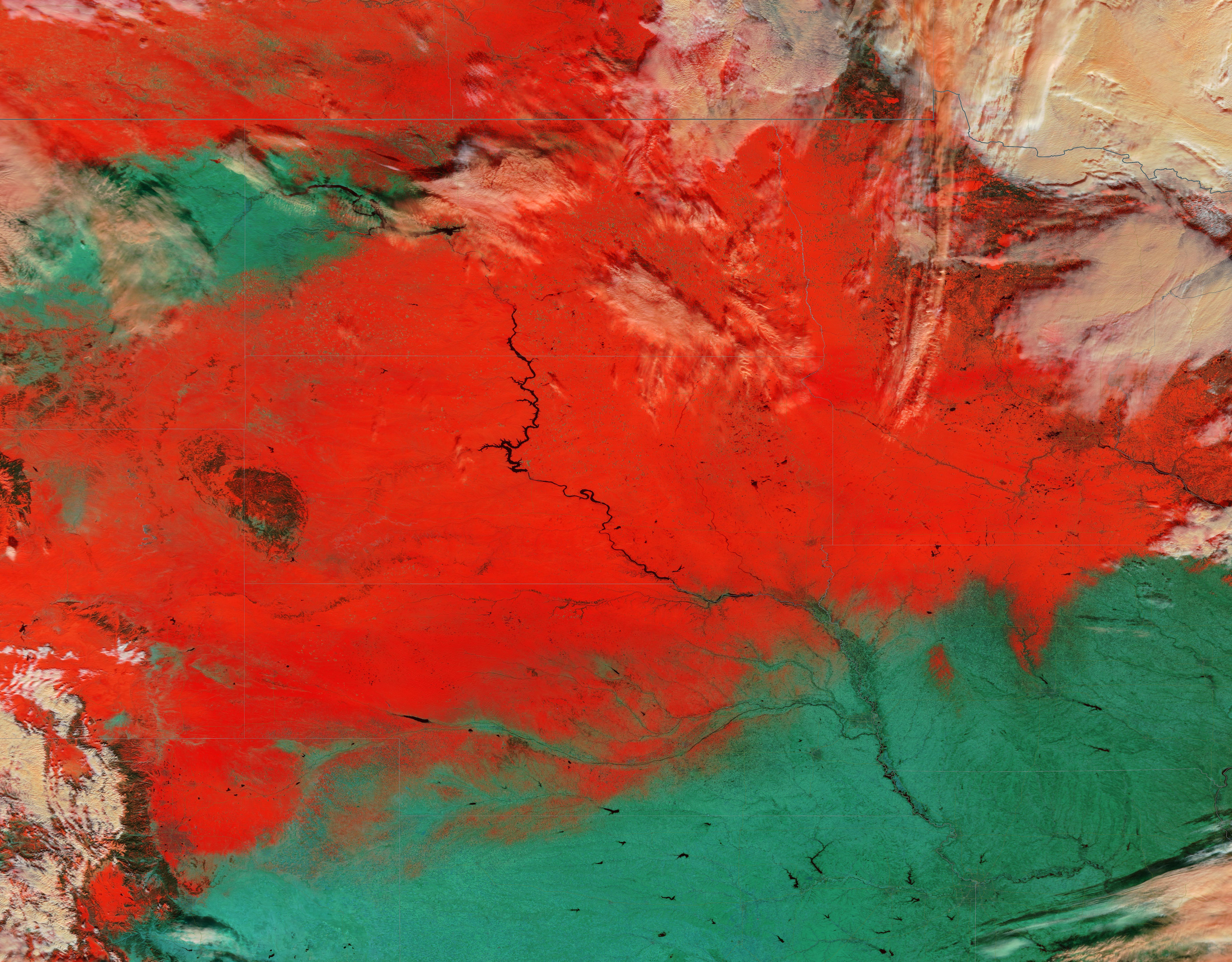
English: A strong storm swept across the United States between November 26 and December 3, 2019, leaving a wide swath of snow that stretched from the West Coast to the East Coast. According to The Weather Channel, the storm first began off the coast of Oregon and northwestern California as a “bomb cyclone”, which is a storm in which the minimum central pressure drops 24 millibars or more within 24 hours. This storm’s central pressure dropped 43 millibars in 24 hours. Once the storm moved from the Pacific Ocean onto land, it made its way across California and Oregon, then the upper Midwest where it merged with a subtropical jet stream moving from Mexico. This powerful double-punch brought blizzard conditions and heavy snowfall from, dumping more than two feet of snow in ten states before crossing New York and New England and reaching Atlantic Ocean on December 3.
Cedar Grove, California, and Utah’s Snowbasin Resort were the winners in the snowfall category, racking up 49 in and 48 in, respectively. By December 2, snow was covering about 46.2 percent of the land of the Lower 48 states, which is the largest area on December 2 since NOAA began collecting snow cover records. On average, only about one-fourth of the Lower 48 carry snow on the ground on that date. On December 3, the National Weather Service released a map which showed at least 19 states had at least one area with a foot or more of snow. The Moderate Resolution Imaging Spectroradiometer (MODIS) on board NASA’s Terra satellite acquired a stunning false-color image of the aftermath of the storm in the Midwest on December 3. This image is centered in South Dakota, with the Black Hills appearing as an oval in the southwest and the Missouri river flowing through the center. False-color images are often used to enhance visualization of snow and ice, especially to help distinguish them from cloud. In true-color images, both cloud and snow appear white and are difficult to separate. When MODIS bands 3-6-7 are combined, the combination of visible and shortwave infrared show ice and snow as bright red. The more ice in the image, the more robust the color red will be, because more ice equates with stronger absorption of solar radiation in the SWIR region. Clouds tend to appear white, but ice particles in cloud will appear yellow/pink or peach in color. Vegetation appears green while water appears inky black and rock appears dark tan or black. |
||
| Date | Taken on 3 December 2019 | ||
| Source |
Snow in the Midwestern United States (direct link)
|
||
| Author | MODIS Land Rapid Response Team, NASA GSFC |
| This media is a product of the Terra mission Credit and attribution belongs to the mission team, if not already specified in the "author" row |
Licensing edit
.jpg&action=edit§ion=2)
| This file is in the public domain in the United States because it was solely created by NASA. NASA copyright policy states that "NASA material is not protected by copyright unless noted". (See Template:PD-USGov, NASA copyright policy page or JPL Image Use Policy.) | ||
 |
Warnings:
|
File history
Click on a date/time to view the file as it appeared at that time.
| Date/Time | Thumbnail | Dimensions | User | Comment | |
|---|---|---|---|---|---|
| current | 02:46, 17 February 2024 | | 7,242 × 5,656 (16.03 MB) | OptimusPrimeBot (talk | contribs) | #Spacemedia - Upload of http://modis.gsfc.nasa.gov/gallery/images/image12072019_250m.jpg via Commons:Spacemedia |
You cannot overwrite this file.
File usage on Commons
There are no pages that use this file.
.jpg&oldid=852927924)