File:Solana Casa Real 09.jpg

Size of this preview: 800 × 600 pixels. Other resolutions: 320 × 240 pixels | 640 × 480 pixels | 1,024 × 768 pixels | 1,280 × 960 pixels | 2,560 × 1,920 pixels | 5,184 × 3,888 pixels.
Original file (5,184 × 3,888 pixels, file size: 4.43 MB, MIME type: image/jpeg)
Captions
Captions
Solana Casa Real
Summary edit
| Description |
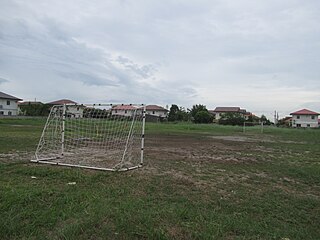
English: Solana Plaza Casa Real (Las Palmas, Avila, Segovia, La Tierra) 43 hectares divided into enclaves by Solana Land Development Corporation Jardin Solana - Casa Real was the provincial building in 1757 when Bacolor was the provincial capital of Pampanga under the Spanish rule - Macabacle and Sitio Banlic, Barangay Cabalantian along Jose Abad Santos Avenue JASA, formerly Olongapo-Gapan-San Fernando road). |
| Date | |
| Source | Own work |
| Author | E911a |
| Camera location | | View this and other nearby images on: OpenStreetMap |
|---|
Macabacle, Bacolor, Pampanga Cabalantian, Bacolor
Licensing edit
I, the copyright holder of this work, hereby publish it under the following license:
This file is licensed under the Creative Commons Attribution-Share Alike 4.0 International license.
- You are free:
- to share – to copy, distribute and transmit the work
- to remix – to adapt the work
- Under the following conditions:
- attribution – You must give appropriate credit, provide a link to the license, and indicate if changes were made. You may do so in any reasonable manner, but not in any way that suggests the licensor endorses you or your use.
- share alike – If you remix, transform, or build upon the material, you must distribute your contributions under the same or compatible license as the original.
File history
Click on a date/time to view the file as it appeared at that time.
| Date/Time | Thumbnail | Dimensions | User | Comment | |
|---|---|---|---|---|---|
| current | 12:30, 27 August 2023 | | 5,184 × 3,888 (4.43 MB) | E911a (talk | contribs) | Uploaded own work with UploadWizard |
You cannot overwrite this file.
File usage on Commons
The following 2 pages use this file: