File:Solar greenhouse owned and built by Peter Howell, located at about the 8,500 foot level in the front range..., 05-1975. (6919962196).jpg

Original file (2,027 × 3,000 pixels, file size: 440 KB, MIME type: image/jpeg)
Captions
Captions
Summary
edit.jpg&action=edit§ion=1)
| Description |
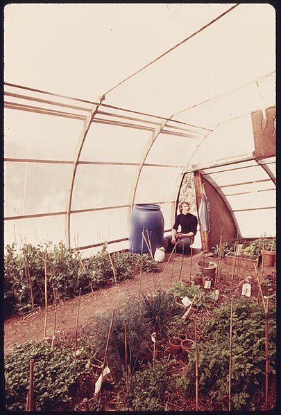
Original Caption: Solar greenhouse owned and built by Peter Howell, located at about the 8,500 foot level in the front range. Using arches from a qounset hut, the structure was covered with two layers of 10 mil vinyl with a dead air space of four inches. Blackened 55-gallon oil drums filled with water absorb heat during the day and lose it at night to prevent drastic temperature changes. Crops such as lettuce and peas were grown all winter. In may with a foot of snow and a temperature of 35 degrees, it was 80 degrees inside, 05/1975. U.S. National Archives’ Local Identifier: 412-DA-14870 Photographer: Norton, Boyd Subjects: Environmental protection Natural resources Pollution Denver (Colorado, United States) inhabited place Persistent URL: research.archives.gov/description/557322 Repository: Still Picture Records Section, Special Media Archives Services Division (NWCS-S), National Archives at College Park, 8601 Adelphi Road, College Park, MD, 20740-6001. For information about ordering reproductions of photographs held by the Still Picture Unit, visit: www.archives.gov/research/order/still-pictures.html Reproductions may be ordered via an independent vendor. NARA maintains a list of vendors at www.archives.gov/research/order/vendors-photos-maps-dc.html Access Restrictions: Unrestricted Use Restrictions: Unrestricted |
| Date | Taken in May 1975 |
| Source | Solar greenhouse owned and built by Peter Howell, located at about the 8,500 foot level in the front range..., 05/1975. |
| Author | The U.S. National Archives |
| Permission (Reusing this file) |
The U.S. National Archives @ Flickr Commons |
| Camera location | | View this and other nearby images on: OpenStreetMap |
|---|
.jpg¶ms=039.737158_N_-104.988784_E_globe:Earth_type:camera_source:Flickr_&language=en)
Licensing
edit.jpg&action=edit§ion=2)
This image was taken from Flickr's The Commons. The uploading organization may have various reasons for determining that no known copyright restrictions exist, such as:
More information can be found at https://flickr.com/commons/usage/. Please add additional copyright tags to this image if more specific information about copyright status can be determined. See Commons:Licensing for more information. |
| This image was originally posted to Flickr by The U.S. National Archives at https://flickr.com/photos/35740357@N03/6919962196. It was reviewed on 22 November 2016 by FlickreviewR and was confirmed to be licensed under the terms of the No known copyright restrictions. |
File history
Click on a date/time to view the file as it appeared at that time.
| Date/Time | Thumbnail | Dimensions | User | Comment | |
|---|---|---|---|---|---|
| current | 03:13, 22 November 2016 | | 2,027 × 3,000 (440 KB) | Victorgrigas (talk | contribs) | Transferred from Flickr via Flickr2Commons |
You cannot overwrite this file.
File usage on Commons
There are no pages that use this file.
.jpg&oldid=886386671)