File:Soldiers' Monument, Bath, New York - 20220312.jpg

Size of this preview: 449 × 599 pixels. Other resolutions: 180 × 240 pixels | 360 × 480 pixels | 576 × 768 pixels | 768 × 1,024 pixels | 1,536 × 2,048 pixels | 2,852 × 3,803 pixels.
Original file (2,852 × 3,803 pixels, file size: 4.28 MB, MIME type: image/jpeg)
Captions
Captions
Add a one-line explanation of what this file represents
Summary edit
| Description |
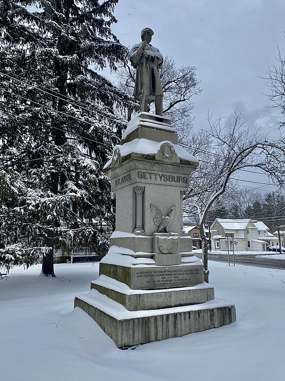
English: Seen in March 2022 at the corner of Haverling and Geneva Streets just north of downtown Bath, New York is this proud stone monument dedicated "in memory of the men from this town who laid down their lives for their country during the War of the Rebellion, 1861-1865" and "erected by voluntary contributions of the citizens of Bath". The inscription on the pedestal gives a date of 1882, but in fact it was not until February of the following year that this 40-ton slab of blue Westerly granite was hauled into town from the quarry in Rhose Island from whence it came. News coverage of the unveiling describe the monument in breathless terms as one "in which Bath may indulge a pride that is pardonable, for it is by far the most finished, artistic and attractive structure not only within the narrow limits of our town, but exceeding in beauty any similar work in this part of the state" and which "will stand the bright, particular ornament of the village, the admired of all beholders, the beautiful expression of patriotic remembrance, for long, long years after the eyes of today have ceased to admire, and our voices of praise or cavil have become silent forever". Twenty-four feet in height, an astonishingly lifelike figure of a soldier dressed in Civil War garb, musket in hand, stands atop a pedestal containing stylized engravings of a shield, an eagle, and the Great Seal of the United States and the New York state seal, as well as the names of the four battles in which the local regiment suffered its heaviest losses: Gettysburg, Mobile, Antietam, and Atlanta. The monument was originally located at Washington Park in the center of downtown and appears to have been moved to its current site in roughly the 1960s or '70s. |
| Date | |
| Source | Own work |
| Author | Andre Carrotflower |
| Camera location | | View this and other nearby images on: OpenStreetMap |
|---|
Licensing edit
I, the copyright holder of this work, hereby publish it under the following license:
This file is licensed under the Creative Commons Attribution-Share Alike 4.0 International license.
- You are free:
- to share – to copy, distribute and transmit the work
- to remix – to adapt the work
- Under the following conditions:
- attribution – You must give appropriate credit, provide a link to the license, and indicate if changes were made. You may do so in any reasonable manner, but not in any way that suggests the licensor endorses you or your use.
- share alike – If you remix, transform, or build upon the material, you must distribute your contributions under the same or compatible license as the original.
File history
Click on a date/time to view the file as it appeared at that time.
| Date/Time | Thumbnail | Dimensions | User | Comment | |
|---|---|---|---|---|---|
| current | 08:29, 14 March 2022 | | 2,852 × 3,803 (4.28 MB) | Andre Carrotflower (talk | contribs) | Uploaded own work with UploadWizard |
You cannot overwrite this file.
File usage on Commons
There are no pages that use this file.