File:Solomon Islands and Oceania.jpg
No higher resolution available.
Solomon_Islands_and_Oceania.jpg (416 × 302 pixels, file size: 14 KB, MIME type: image/jpeg)
Captions
Captions
Add a one-line explanation of what this file represents
Summary edit
| Description |
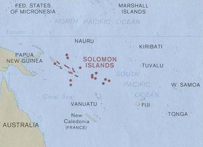
English: Map of Solomon Islands. |
| Date | |
| Source |
|
| Author | U.S. Central Intelligence Agency |
| Permission (Reusing this file) |
Public domain |
Licensing edit
| This image is a work of a Central Intelligence Agency employee, taken or made as part of that person's official duties. As a Work of the United States Government, this image or media is in the public domain in the United States.
|

|
Original upload log edit
The original description page was here. All following user names refer to en.wikipedia.
- 2003-08-10 09:57 Pascal 416×302× (14736 bytes) Map of Solomon Islands and where they are from http://www.lib.utexas.edu/maps/australia.html
File history
Click on a date/time to view the file as it appeared at that time.
| Date/Time | Thumbnail | Dimensions | User | Comment | |
|---|---|---|---|---|---|
| current | 19:44, 25 April 2009 | | 416 × 302 (14 KB) | File Upload Bot (Magnus Manske) (talk | contribs) | {{BotMoveToCommons|en.wikipedia|year={{subst:CURRENTYEAR}}|month={{subst:CURRENTMONTHNAME}}|day={{subst:CURRENTDAY}}}} {{Information |Description={{en|Map of Solomon Islands<br/> en:Category:Maps of the Solomon Islands}} |Source=Transferred from [ |
You cannot overwrite this file.
File usage on Commons
There are no pages that use this file.
File usage on other wikis
The following other wikis use this file:
- Usage on ar.wikipedia.org
- Usage on en.wikipedia.org
- Usage on es.wikipedia.org
- Usage on fr.wikipedia.org
- Usage on hr.wikipedia.org
- Usage on io.wikipedia.org