File:Sonntag Stein Großwalsertal 01.JPG
Size of this preview: 800 × 531 pixels. Other resolutions: 320 × 213 pixels | 640 × 425 pixels | 1,024 × 680 pixels | 1,280 × 850 pixels | 2,560 × 1,700 pixels | 4,288 × 2,848 pixels.
Original file (4,288 × 2,848 pixels, file size: 3.04 MB, MIME type: image/jpeg)
File information
Structured data
Captions
DescriptionSonntag Stein Großwalsertal 01.JPG |
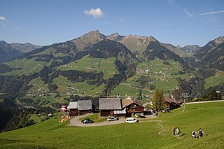
Deutsch: Wanderung von Sonntag, Stein nach Alpe Oberpartnom. (Partum). Blick von der Bergstation der Seilbahn auf Fontanella, Faschina und die Damülser Mittagsspitze. |
||
Date | |||
Source | Own work | ||
Author |
|
||
Permission (Reusing this file) |
I, the copyright holder of this work, hereby publish it under the following licenses:
This file is licensed under the Creative Commons Attribution-Share Alike 3.0 Austria license.
You may select the license of your choice. |
Camera location | 47° 13′ 51.07″ N, 9° 55′ 22.03″ E | View this and other nearby images on: OpenStreetMap | 47.230853; 9.922786 |
---|
}}
}}
Annotations InfoField | This image is annotated: View the annotations at Commons |
2214
542
43
43
4288
2848
Glatthorn
3377
794
43
43
4288
2848
Damülser Mittagsspitze
3505
971
155
91
4288
2848
Faschina
2600
1255
563
300
4288
2848
Fontanella
574
1614
702
231
4288
2848
Sonnatg
File history
Click on a date/time to view the file as it appeared at that time.
Date/Time | Thumbnail | Dimensions | User | Comment | |
---|---|---|---|---|---|
current | 21:18, 11 January 2013 | 4,288 × 2,848 (3.04 MB) | Böhringer (talk | contribs) | User created page with UploadWizard |
You cannot overwrite this file.
File usage on Commons
There are no pages that use this file.
File usage on other wikis
The following other wikis use this file:
- Usage on el.wikipedia.org
- Usage on en.wikipedia.org
- Usage on nl.wikipedia.org
- Usage on ru.wikipedia.org
Metadata
This file contains additional information such as Exif metadata which may have been added by the digital camera, scanner, or software program used to create or digitize it. If the file has been modified from its original state, some details such as the timestamp may not fully reflect those of the original file. The timestamp is only as accurate as the clock in the camera, and it may be completely wrong.
Camera manufacturer | NIKON CORPORATION |
---|---|
Camera model | NIKON D300S |
Copyright holder | Boehringer Friedrich |
Exposure time | 1/250 sec (0.004) |
F-number | f/8 |
Date and time of data generation | 15:13, 2 October 2011 |
Lens focal length | 16 mm |
Latitude | 47° 13′ 50.08″ N |
Longitude | 9° 55′ 21.98″ E |
Altitude | 1,344 meters above sea level |
Orientation | Normal |
Horizontal resolution | 300 dpi |
Vertical resolution | 300 dpi |
Software used | Ver.1.00 |
File change date and time | 15:13, 2 October 2011 |
Y and C positioning | Co-sited |
Exposure Program | Normal program |
Exif version | 2.21 |
Date and time of digitizing | 15:13, 2 October 2011 |
Meaning of each component |
|
Image compression mode | 2 |
APEX exposure bias | 0 |
Maximum land aperture | 3.6 APEX (f/3.48) |
Metering mode | Pattern |
Light source | Unknown |
Flash | Flash did not fire |
DateTime subseconds | 65 |
DateTimeOriginal subseconds | 65 |
DateTimeDigitized subseconds | 65 |
Supported Flashpix version | 1 |
Color space | sRGB |
Sensing method | One-chip color area sensor |
File source | Digital still camera |
Scene type | A directly photographed image |
Custom image processing | Normal process |
Exposure mode | Auto exposure |
White balance | Auto white balance |
Digital zoom ratio | 1 |
Focal length in 35 mm film | 24 mm |
Scene capture type | Standard |
Scene control | None |
Contrast | Normal |
Saturation | Normal |
Sharpness | Hard |
Subject distance range | Unknown |
GPS time (atomic clock) | 12:12 |
Satellites used for measurement | 04 |
Geodetic survey data used | WGS 84 |
GPS date | 2 October 2011 |
GPS tag version | 2.2.0.0 |