File:Sonoma Lake aerial view-edit.jpg

Size of this preview: 800 × 503 pixels. Other resolutions: 320 × 201 pixels | 640 × 402 pixels | 877 × 551 pixels.
Original file (877 × 551 pixels, file size: 704 KB, MIME type: image/jpeg)
Captions
Captions
Add a one-line explanation of what this file represents
| Description |
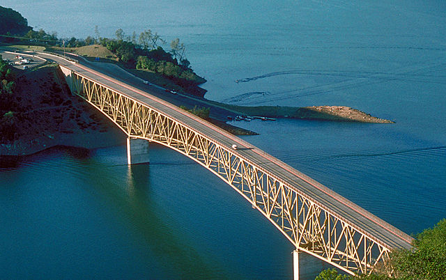
English: Aerial view of Lake Sonoma on Dry Creek in Sonoma County, California, USA. The lake is impounded by Warm Springs Dam, constructed in 1983 by the U.S. Army Corps of Engineers for flood control and water supply. The dam is just off to the right and is not visible in this picture. View is to the northwest.
Coordinates: 38°43′8.04″N 123°0′47.62″W / 38.7189°N 123.0132278°W |
|||
| Date | not specified or unknown | |||
| Source |
U.S. Army Corps of Engineers Digital Visual Library Image page Image description page Digital Visual Library home page |
|||
| Author | U.S. Army Corps of Engineers, photographer not specified or unknown | |||
| Permission (Reusing this file) |
|
|||
| Other versions |
|
|||
| Location | Sonoma County, California, USA |

| This is a retouched picture, which means that it has been digitally altered from its original version. Modifications: cropped, colors edited. Modifications made by Glabb.
|
File history
Click on a date/time to view the file as it appeared at that time.
| Date/Time | Thumbnail | Dimensions | User | Comment | |
|---|---|---|---|---|---|
| current | 09:45, 27 June 2010 | | 877 × 551 (704 KB) | Glabb (talk | contribs) | {{Information | Description = {{en|Aerial view of Lake Sonoma on Dry Creek in Sonoma County, California, USA. The lake is impounded by Warm Springs Dam, constructed in 1983 by the U.S. Army Corps of Engineers for flood control and water supply. The dam |
You cannot overwrite this file.
File usage on Commons
The following 2 pages use this file:
File usage on other wikis
The following other wikis use this file:
- Usage on de.wikipedia.org
- Usage on fr.wikipedia.org
- Usage on www.wikidata.org