File:Sorkwity (gmina) location map.png

Original file (1,444 × 2,729 pixels, file size: 609 KB, MIME type: image/png)
Captions
Captions
Summary
edit_location_map.png&action=edit§ion=1)
| Description |
English: Location map |
| Date | |
| Source | Own work |
| Author | Smat |
| Description |
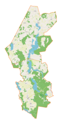
Polski: Mapa gminy Sorkwity, Polska
English: Map of Sorkwity (gmina), Poland |
|||||||||
| Date | ||||||||||
| Source | You may find a page on the OpenStreetMap wiki page for Sorkwity (gmina) | |||||||||
| Creator |
OpenStreetMap contributors OpenStreetMap contributors |
|||||||||
| Permission (Reusing this file) |
OpenStreetMap data is available under the Open Database License (details). Map tiles are licensed under the Creative Commons Attribution-ShareAlike 2.0 license (CC-BY-SA 2.0).
This file is licensed under the Creative Commons Attribution-Share Alike 2.0 Generic license.
|
|||||||||
| Geotemporal data | ||||||||||
| Bounding box |
|
|||||||||
| Georeferencing | If inappropriate please set warp_status = skip to hide. | |||||||||
Licensing
edit_location_map.png&action=edit§ion=2)
| This work contains information from OpenStreetMap, which is made available under the Open Database License (ODbL).
The ODbL does not require any particular license for maps produced from ODbL data. Prior to 1 August 2020, map tiles produced by the OpenStreetMap Foundation were licensed under the CC-BY-SA-2.0 license. Maps produced by other people may be subject to other licences. |
File history
Click on a date/time to view the file as it appeared at that time.
| Date/Time | Thumbnail | Dimensions | User | Comment | |
|---|---|---|---|---|---|
| current | 09:38, 29 April 2019 | | 1,444 × 2,729 (609 KB) | Smat (talk | contribs) | User created page with UploadWizard |
You cannot overwrite this file.
File usage on Commons
There are no pages that use this file.
File usage on other wikis
The following other wikis use this file:
- Usage on de.wikipedia.org
- Usage on pl.wikipedia.org
- Warpuny
- Borowski Las
- Burszewo
- Gizewo
- Jełmuń
- Piłakno
- Maradki
- Nibork
- Pustniki
- Sorkwity
- Stary Gieląd
- Surmówka
- Stama
- Zyndaki
- Borowe (województwo warmińsko-mazurskie)
- Choszczewo (województwo warmińsko-mazurskie)
- Jędrychowo (powiat mrągowski)
- Kozłowo (powiat mrągowski)
- Rozogi (powiat mrągowski)
- Rybno (powiat mrągowski)
- Szymanowo (powiat mrągowski)
- Babięty Małe (jezioro)
- Janiszewo (województwo warmińsko-mazurskie)
- Młynik (województwo warmińsko-mazurskie)
- Miłuki (powiat mrągowski)
- Szarłaty
- Wola Maradzka
- Głodowo (Maradki)
- Karczewiec (Rybno)
- Załuki (województwo warmińsko-mazurskie)
- Janowo (powiat mrągowski)
- Kozarek Mały
- Zamkowo
- Szelągówka (województwo warmińsko-mazurskie)
- Maradzki Chojniak
- Bałowo (powiat mrągowski)
- Gieląd Mały
- Kozarek Wielki
- Lesiny (Kozłowo)
- Nowy Gieląd
- Piłak
- Słomowo (województwo warmińsko-mazurskie)
- Tyszkowo
- Wilamówko (Maradki)
- Jezioro Lampackie
- Rodowo (powiat mrągowski)
- Parafia św. Bonifacego w Rybnie
- Lampasz
- Rezerwat przyrody Piłaki
View more global usage of this file.
_location_map.png)
_location_map.png&oldid=704004168)