File:Sotzmann Grundriss der Königlichen Residenzstädte Berlin 1792.jpg
Size of this preview: 800 × 533 pixels. Other resolutions: 320 × 213 pixels | 640 × 426 pixels | 1,024 × 682 pixels | 1,280 × 853 pixels | 2,499 × 1,665 pixels.
Original file (2,499 × 1,665 pixels, file size: 1.71 MB, MIME type: image/jpeg)
Captions
Captions
Add a one-line explanation of what this file represents
Summary edit
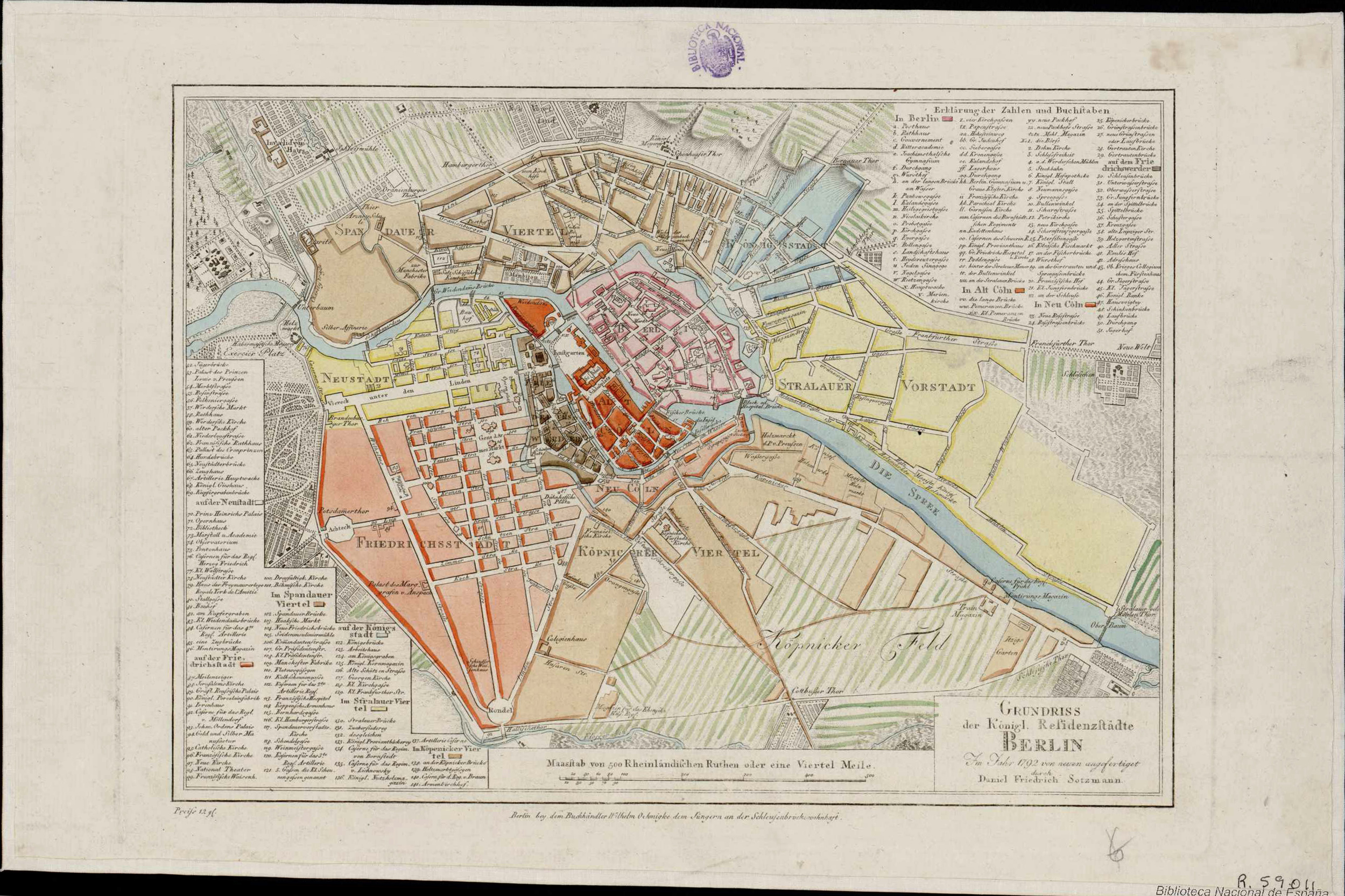
| Title |
Grundriss der Konigl. Residenzstadte Berlin |
|||||||||
| Description |
Deutsch: Erschienen in: "Neuester Wegweiser durch die Koenigl. Preussischen Staaten [..]" von I.D.F. Rumpf |
|||||||||
| Date | ||||||||||
| Source | Biblioteca Digital Hispánica (online) | |||||||||
| Creator |
Daniel Friedrich Sotzmann |
|||||||||
| Geotemporal data | ||||||||||
| Map location | Berlin | |||||||||
| Scale | 1:19,500 | |||||||||
| Heading |
 |
|||||||||
| Bounding box |
|
|||||||||
| Georeferencing | If inappropriate please set warp_status = skip to hide. | |||||||||
| Bibliographic data | ||||||||||
| Language | German | |||||||||
| Archival data | ||||||||||
| Collection | Biblioteca Nacional de España | |||||||||
| Accession number |
MR/7/II SERIE 06/035 |
|||||||||
| Dimensions | height: 19.8 cm (7.7 in); width: 30.7 cm (12 in) (map size) | |||||||||
| Medium | colored copper engraving print | |||||||||
| Notes |
Literatur
|
|||||||||
Licensing edit
|
This is a faithful photographic reproduction of a two-dimensional, public domain work of art. The work of art itself is in the public domain for the following reason:
The official position taken by the Wikimedia Foundation is that "faithful reproductions of two-dimensional public domain works of art are public domain".
This photographic reproduction is therefore also considered to be in the public domain in the United States. In other jurisdictions, re-use of this content may be restricted; see Reuse of PD-Art photographs for details. | ||||
File history
Click on a date/time to view the file as it appeared at that time.
| Date/Time | Thumbnail | Dimensions | User | Comment | |
|---|---|---|---|---|---|
| current | 19:42, 14 January 2016 | | 2,499 × 1,665 (1.71 MB) | Alexrk2 (talk | contribs) | {{InteractiveViewer}} == {{int:description}} == {{Map |title='''Grundriss der Konigl. Residenzstadte Berlin''' |description={{de|Erschienen in: "Neuester Wegweiser durch die Koenigl. Preussischen Staaten [..]" von I.D.F. Rumpf}} |legend= |author=Daniel... |
You cannot overwrite this file.
File usage on Commons
There are no pages that use this file.