File:Sources GIS Coast-fr.svg

Size of this PNG preview of this SVG file: 800 × 527 pixels. Other resolutions: 320 × 211 pixels | 640 × 422 pixels | 1,024 × 675 pixels | 1,280 × 843 pixels | 2,560 × 1,687 pixels | 4,052 × 2,670 pixels.
Original file (SVG file, nominally 4,052 × 2,670 pixels, file size: 208 KB)
Captions
Captions
Add a one-line explanation of what this file represents
Summary edit
| Description |
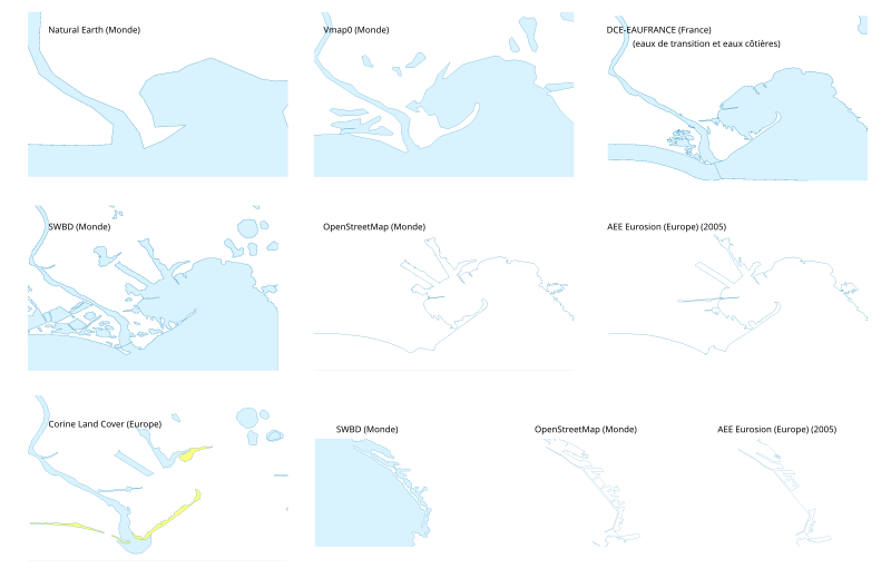
Français : Comparaisons de différentes sources de données vectorielles, pour les étendues d'eau et les côtes, utilisables dans un logiciel SIG. Cartes de l'embouchure du Rhône et de la façade de Marseille. Cliquer sur l'image pour mieux voir le bitmap embarqué. English: Comparison between some vector GIS sources. |
| Date | |
| Source | Own work ; USGS SWBD, Natural Earth, Corine Land Cover, données de la carte © les contributeurs d'OpenStreetMap, CC-BY-SA Openstreetmap via OSMdata, Vmap0 via gis-lab, eaufrance.fr. Capture d'écran du logiciel QGIS |
| Author | Bourrichon |
Licensing edit
I, the copyright holder of this work, hereby publish it under the following license:
This file is licensed under the Creative Commons Attribution-Share Alike 3.0 Unported license.
- You are free:
- to share – to copy, distribute and transmit the work
- to remix – to adapt the work
- Under the following conditions:
- attribution – You must give appropriate credit, provide a link to the license, and indicate if changes were made. You may do so in any reasonable manner, but not in any way that suggests the licensor endorses you or your use.
- share alike – If you remix, transform, or build upon the material, you must distribute your contributions under the same or compatible license as the original.
File history
Click on a date/time to view the file as it appeared at that time.
| Date/Time | Thumbnail | Dimensions | User | Comment | |
|---|---|---|---|---|---|
| current | 23:26, 25 February 2013 | | 4,052 × 2,670 (208 KB) | Bourrichon (talk | contribs) | correction |
| 23:18, 25 February 2013 |  | 4,052 × 2,670 (208 KB) | Bourrichon (talk | contribs) | =={{int:filedesc}}== {{Information |description={{fr|1=Comparaisons de différentes sources de données vectorielles, pour les étendues d'eau et les côtes, utilisables dans un logiciel SIG. '''Cliquer sur l'image pour mieux voir le bitmap... |
You cannot overwrite this file.
File usage on Commons
There are no pages that use this file.
File usage on other wikis
The following other wikis use this file:
- Usage on fr.wikipedia.org