File:South West Yorks green belt.svg

Size of this PNG preview of this SVG file: 535 × 600 pixels. Other resolutions: 214 × 240 pixels | 428 × 480 pixels | 685 × 768 pixels | 913 × 1,024 pixels | 1,826 × 2,048 pixels | 1,170 × 1,312 pixels.
Original file (SVG file, nominally 1,170 × 1,312 pixels, file size: 3.75 MB)
Captions
Captions
Add a one-line explanation of what this file represents
Summary edit
| Description |
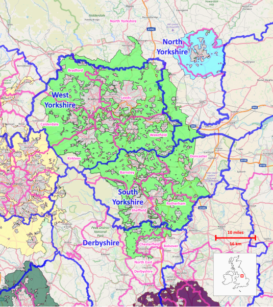
English: Green belt showing extents and counties. |
| Date | |
| Source | OpenMap and Department for Communities and Local Government. |
| Author |
This is a derivative work of an Open Street Map, licensed under the Creative Commons Attribution-ShareAlike 4.0 licence. The underlying map is © OpenStreetMap contributors. http://www.openstreetmap.org. The boundaries for the overlays were sourced from the Department for Communities and Local Government and contains public sector information licensed under the Open Government Licence v3.0 |
| Camera location | | View this and other nearby images on: OpenStreetMap |
|---|
Other nearby belts partially shown: Blue - York Green Belt Yellow - North West Green Belt
Licensing edit
This file is licensed under the Creative Commons Attribution-Share Alike 4.0 International license.
- You are free:
- to share – to copy, distribute and transmit the work
- to remix – to adapt the work
- Under the following conditions:
- attribution – You must give appropriate credit, provide a link to the license, and indicate if changes were made. You may do so in any reasonable manner, but not in any way that suggests the licensor endorses you or your use.
- share alike – If you remix, transform, or build upon the material, you must distribute your contributions under the same or compatible license as the original.
File history
Click on a date/time to view the file as it appeared at that time.
| Date/Time | Thumbnail | Dimensions | User | Comment | |
|---|---|---|---|---|---|
| current | 11:38, 27 March 2024 | | 1,170 × 1,312 (3.75 MB) | The Equalizer (talk | contribs) | Removed abolished district boundaries |
| 00:44, 22 November 2023 |  | 1,248 × 1,400 (3.21 MB) | The Equalizer (talk | contribs) | Reverted to version as of 00:27, 22 November 2023 (UTC) | |
| 00:43, 22 November 2023 |  | 1,248 × 1,400 (3.21 MB) | The Equalizer (talk | contribs) | Removed abolished districts | |
| 00:27, 22 November 2023 |  | 1,248 × 1,400 (3.21 MB) | The Equalizer (talk | contribs) | Reverted to version as of 12:38, 22 March 2018 (UTC) | |
| 00:26, 22 November 2023 |  | 1,248 × 1,400 (3.21 MB) | The Equalizer (talk | contribs) | Upload correct image | |
| 00:23, 22 November 2023 |  | 744 × 1,052 (3.21 MB) | The Equalizer (talk | contribs) | Upload correct image | |
| 21:27, 11 November 2023 |  | 1,248 × 1,400 (3.21 MB) | The Equalizer (talk | contribs) | Removed abolished districts | |
| 12:38, 22 March 2018 |  | 1,248 × 1,400 (3.21 MB) | The Equalizer (talk | contribs) | Lengthened again top and bottom, added other green belt areas | |
| 01:30, 22 March 2018 |  | 1,248 × 1,248 (2.96 MB) | The Equalizer (talk | contribs) | Lengthened map, added scale, inset map | |
| 06:33, 25 December 2017 |  | 1,248 × 1,066 (2.57 MB) | The Equalizer (talk | contribs) | Added districts |
You cannot overwrite this file.
File usage on Commons
There are no pages that use this file.
File usage on other wikis
The following other wikis use this file:
- Usage on en.wikipedia.org