File:South Wingfield Station (2) (geograph 3189890).jpg
Size of this preview: 800 × 600 pixels. Other resolutions: 320 × 240 pixels | 640 × 480 pixels | 1,024 × 768 pixels | 1,280 × 960 pixels | 2,560 × 1,920 pixels | 3,648 × 2,736 pixels.
Original file (3,648 × 2,736 pixels, file size: 4.44 MB, MIME type: image/jpeg)
Captions
Captions
Add a one-line explanation of what this file represents
Summary edit
_(geograph_3189890).jpg&action=edit§ion=1)
| Description |
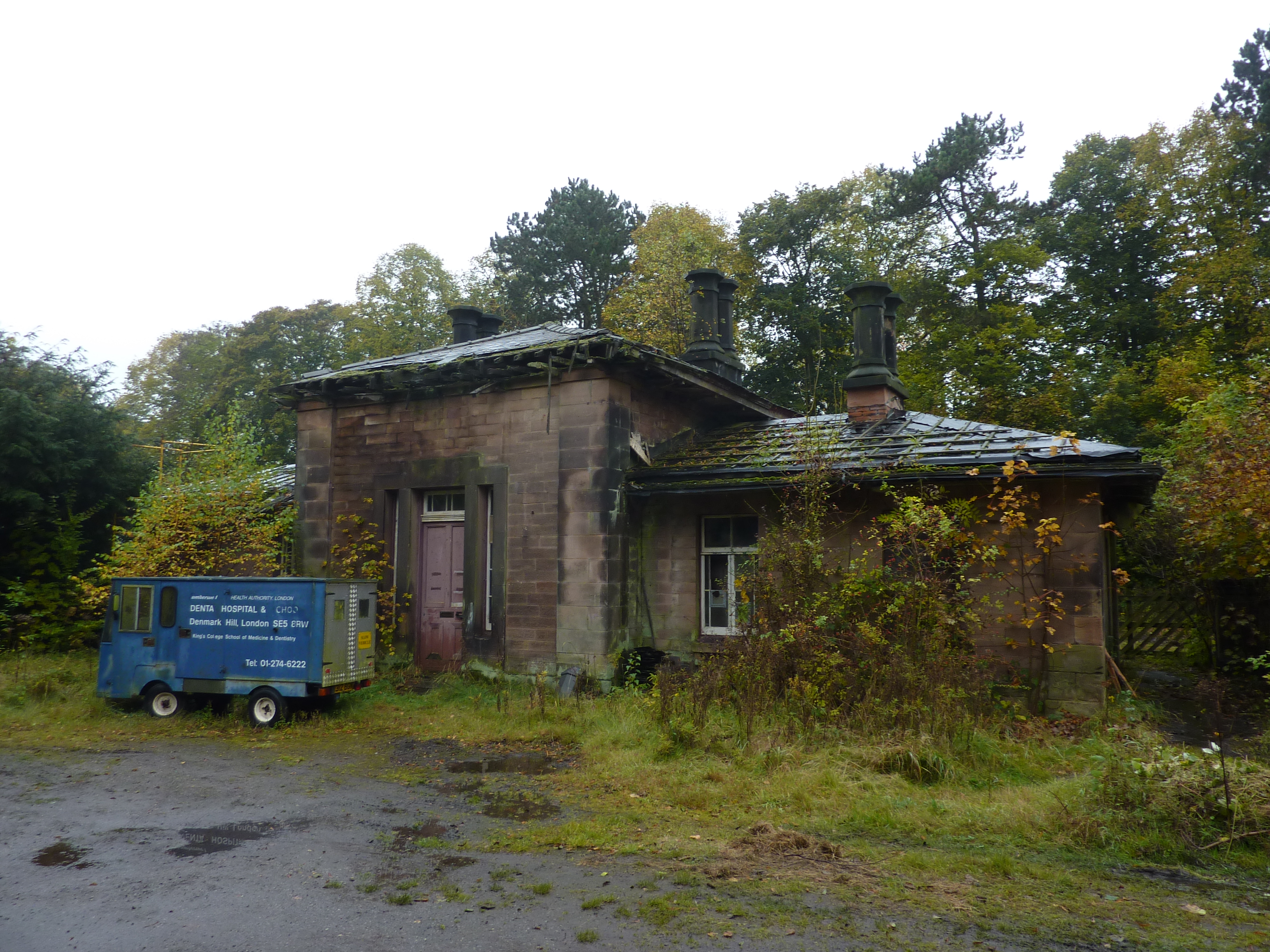
English: South Wingfield Station [2] Or what remains of it. The Victorian Society have issued a list of the ten most threatened heritage structures in England and Wales. A Grade II Listed building,the railway station was built by the North Midland Railway,designed by Francis Thompson.The line on which it stands runs from Ambergate, to the south, north to Chesterfield.The station was closed in 1967. "It has been said that Francis Thompson's best work was on the North Midland Railway, between Derby and Leeds. The only example still surviving is at Wingfield. Built in 1840,it is a single storey ashlar building in Georgian style with overhanging eaves. The station name was carved in gilt lettering on the facade, around an ornamental clock(now absent). It was closed in 1967 and is in poor condition. Christian Barman, who wrote one of the first studies of railway architecture, called it 'the most perfect of all station houses'." (From "Our Transport Heritage"). |
| Date | |
| Source | From geograph.org.uk |
| Author | Peter Barr |
| Permission (Reusing this file) |
Creative Commons Attribution Share-alike license 2.0 |
| Attribution (required by the license) | Peter Barr / South Wingfield Station [2] / |
This is a photo of listed building number 1045917. |
| Camera location | | View this and other nearby images on: OpenStreetMap |
|---|
_(geograph_3189890).jpg¶ms=053.097570_N_-001.426339_E_globe:Earth_type:camera_source:geograph-osgb36(SK38515575)_heading:247.00&language=en)
| Object location | | View this and other nearby images on: OpenStreetMap |
|---|
_(geograph_3189890).jpg¶ms=053.097480_N_-001.426640_E_globe:Earth_class:object_type:object_source:geograph-osgb36(SK38495574)_heading:247.00&language=en)
Licensing edit
_(geograph_3189890).jpg&action=edit§ion=2)

|
This image was taken from the Geograph project collection. See this photograph's page on the Geograph website for the photographer's contact details. The copyright on this image is owned by Peter Barr and is licensed for reuse under the Creative Commons Attribution-ShareAlike 2.0 license.
|
This file is licensed under the Creative Commons Attribution-Share Alike 2.0 Generic license.
Attribution: Peter Barr
- You are free:
- to share – to copy, distribute and transmit the work
- to remix – to adapt the work
- Under the following conditions:
- attribution – You must give appropriate credit, provide a link to the license, and indicate if changes were made. You may do so in any reasonable manner, but not in any way that suggests the licensor endorses you or your use.
- share alike – If you remix, transform, or build upon the material, you must distribute your contributions under the same or compatible license as the original.
File history
Click on a date/time to view the file as it appeared at that time.
| Date/Time | Thumbnail | Dimensions | User | Comment | |
|---|---|---|---|---|---|
| current | 18:41, 13 December 2020 | | 3,648 × 2,736 (4.44 MB) | Lamberhurst (talk | contribs) | Transferred from geograph.co.uk using [https://tools.wmflabs.org/geograph2commons/ geograph2commons] |
You cannot overwrite this file.
File usage on Commons
The following page uses this file:
File usage on other wikis
The following other wikis use this file:
- Usage on en.wikipedia.org
_(geograph_3189890).jpg&oldid=707586904)