File:South end approach, showing roadbed, and surrounding area. Overall view north-northeast. 90 mm lens. - Gault Bridge, Spanning Deer Creek at South Pine Street, Nevada City, Nevada HAER CAL,29-NEVCI,6-5.tif

Size of this JPG preview of this TIF file: 739 × 599 pixels. Other resolutions: 296 × 240 pixels | 592 × 480 pixels | 947 × 768 pixels | 1,262 × 1,024 pixels | 2,525 × 2,048 pixels | 5,000 × 4,056 pixels.
Original file (5,000 × 4,056 pixels, file size: 19.34 MB, MIME type: image/tiff)
Captions
Captions
Add a one-line explanation of what this file represents
Summary edit
| South end approach, showing roadbed, and surrounding area. Overall view north-northeast. 90 mm lens. - Gault Bridge, Spanning Deer Creek at South Pine Street, Nevada City, Nevada County, CA | ||||
|---|---|---|---|---|
| Photographer |
Mahoney, John |
|||
| Title |
South end approach, showing roadbed, and surrounding area. Overall view north-northeast. 90 mm lens. - Gault Bridge, Spanning Deer Creek at South Pine Street, Nevada City, Nevada County, CA |
|||
| Depicted place | California; Nevada County; Nevada City | |||
| Date | 1994 | |||
| Dimensions | 4 x 5 in. | |||
| Current location |
Library of Congress Prints and Photographs Division Washington, D.C. 20540 USA http://hdl.loc.gov/loc.pnp/pp.print |
|||
| Accession number |
HAER CAL,29-NEVCI,6-5 |
|||
| Credit line |
|
|||
| Source | https://www.loc.gov/pictures/item/ca1974.photos.181524p | |||
| Permission (Reusing this file) |
|
|||

| Camera location | | View this and other nearby images on: OpenStreetMap |
|---|
File history
Click on a date/time to view the file as it appeared at that time.
| Date/Time | Thumbnail | Dimensions | User | Comment | |
|---|---|---|---|---|---|
| current | 07:34, 5 July 2014 | 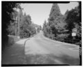 | 5,000 × 4,056 (19.34 MB) | Fæ (talk | contribs) | GWToolset: Creating mediafile for Fæ. HABS 05 July 2014 (401:500) |
You cannot overwrite this file.
File usage on Commons
The following page uses this file: