File:Southeastern Brazil.jpg

Size of this preview: 644 × 599 pixels. Other resolutions: 258 × 240 pixels | 516 × 480 pixels | 825 × 768 pixels | 1,024 × 953 pixels.
Original file (1,024 × 953 pixels, file size: 971 KB, MIME type: image/jpeg)
Captions
Captions
Add a one-line explanation of what this file represents
Summary
edit
| Southeastern Brazil | |
|---|---|
| Photographer |
Envisat satellite |
| Title |
Southeastern Brazil |
| Description |
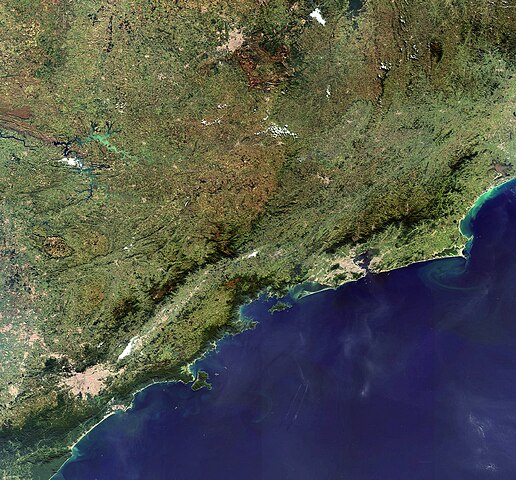
English: This Envisat image highlights the southeastern coast of Brazil, South America’s largest and most populous country. Brazil’s federal district of Sao Paolo is visible in the left half of the image. Other than Sao Paolo, three out of Brazil’s twenty-six states comprise the southeastern region, including Rio de Janeiro, Minas Gerais and Espirito Santo. |
| Depicted place | Brazil |
| Collection | European Space Agency |
| Accession number |
214133 |
| Credit line | ESA |
| Source | http://www.esa.int/spaceinimages/Images/2008/07/Southeastern_Brazil |
Licensing
edit
This file is licensed under the Creative Commons Attribution-ShareAlike 3.0 IGO license.
- You are free:
- to share – to copy, distribute and transmit the work
- to remix – to adapt the work
- Under the following conditions:
- attribution – You must give appropriate credit, provide a link to the license, and indicate if changes were made. You may do so in any reasonable manner, but not in any way that suggests the licensor endorses you or your use.
- share alike – If you remix, transform, or build upon the material, you must distribute your contributions under the same or compatible license as the original.
File history
Click on a date/time to view the file as it appeared at that time.
| Date/Time | Thumbnail | Dimensions | User | Comment | |
|---|---|---|---|---|---|
| current | 13:11, 6 March 2017 | | 1,024 × 953 (971 KB) | Revent (talk | contribs) | =={{int:filedesc}}== {{Photograph |photographer = Envisat satellite |title = Southeastern Brazil |description = {{en|1=This Envisat image highlights the southeastern coast of Brazil, South America’s largest and most popul... |
You cannot overwrite this file.
File usage on Commons
The following 3 pages use this file: