File:Southkoreamap en.png

Size of this preview: 612 × 599 pixels. Other resolutions: 245 × 240 pixels | 490 × 480 pixels | 774 × 758 pixels.
Original file (774 × 758 pixels, file size: 385 KB, MIME type: image/png)
Captions
Captions
Add a one-line explanation of what this file represents
Summary
edit
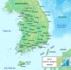
| Description | A map of South Korea, made by the uploader. The map is based on maps from www.demis.nl/wms/mapclip.htm. Names written that they fit en-wp rules (e.g. w:en:Wikipedia:Naming conventions (Korean) |
| Date | (UTC) |
| Source | |
| Author |
|
| Other versions |
 |
| This is a retouched picture, which means that it has been digitally altered from its original version. Modifications: Names changed due to w:en:Wikipedia:Naming conventions (Korean). The original can be viewed here: Southkoreamap.png:
|
Licensing
edit
I, the copyright holder of this work, hereby publish it under the following licenses:
This file is licensed under the Creative Commons Attribution-Share Alike 2.5 Generic, 2.0 Generic and 1.0 Generic license.
- You are free:
- to share – to copy, distribute and transmit the work
- to remix – to adapt the work
- Under the following conditions:
- attribution – You must give appropriate credit, provide a link to the license, and indicate if changes were made. You may do so in any reasonable manner, but not in any way that suggests the licensor endorses you or your use.
- share alike – If you remix, transform, or build upon the material, you must distribute your contributions under the same or compatible license as the original.
| This file is licensed under the Creative Commons Attribution-Share Alike 3.0 Unported license. | ||
| ||
| This licensing tag was added to this file as part of the GFDL licensing update. |

|
Permission is granted to copy, distribute and/or modify this document under the terms of the GNU Free Documentation License, Version 1.2 or any later version published by the Free Software Foundation; with no Invariant Sections, no Front-Cover Texts, and no Back-Cover Texts. A copy of the license is included in the section entitled GNU Free Documentation License. |
This image is in the public domain because it came from the site https://www.demis.nl/products/web-map-server/examples/ and was released by the copyright holder. Permission is granted to copy, distribute and/or modify this map since it is based on free of copyright images from: www.demis.nl. See also approval email on de.wp and its clarification.
|
| This work has been released into the public domain by its copyright holder, www.demis.nl. This applies worldwide. In some countries this may not be legally possible; if so: www.demis.nl grants anyone the right to use this work for any purpose, without any conditions, unless such conditions are required by law.
|
You may select the license of your choice.
Original upload log
edit
This image is a derivative work of the following images:
- File:Southkoreamap.png licensed with Cc-by-sa-2.5,2.0,1.0, Cc-by-sa-3.0-migrated, GFDL, PD-Demis
- 2010-09-05T18:03:31Z Prosfilaes 774x758 (398176 Bytes) Reverted to original version
- 2010-09-04T14:45:45Z Valentim 774x758 (394138 Bytes) Reverted to version as of 12:28, 30 August 2010. Vandalism. User already reported and protection requested.
- 2010-09-04T10:55:46Z Idh0854 774x758 (398176 Bytes) Reverted to version as of 09:00, 30 August 2010 // If you want to last vision, you make new file. And this is no "Vandalism".
- 2010-08-30T12:28:33Z Valentim 774x758 (394138 Bytes) Reverted to version as of 10:22, 29 August 2010. Continuing vandalism of [[User:Idh0854]].
- 2010-08-30T09:00:51Z Idh0854 774x758 (398176 Bytes) Reverted to version as of 07:36, 29 August 2010 // Vandalism.
- 2010-08-29T10:22:02Z Valentim 774x758 (394138 Bytes) Reverted to version as of 17:25, 27 August 2010. Vandalism.
- 2010-08-29T07:36:37Z Idh0854 774x758 (398176 Bytes) Reverted to version as of 15:57, 27 August 2010 // Your contribuion is no POV! So, back to the frist contribution.
- 2010-08-27T17:25:13Z Valentim 774x758 (394138 Bytes) Reverted to version as of 15:10, 22 August 2010. As already said by me and User:84user: Please download your version to a seperate file. Thank you.
- 2010-08-27T15:57:48Z Idh0854 774x758 (398176 Bytes) Reverted to version as of 09:31, 22 August 2010 // Rollback (talk)
- 2010-08-22T15:10:01Z Valentim 774x758 (394138 Bytes) Reverted to version as of 09:05, 22 August 2010. See discussion [[User_talk:Valentim#.EC.A0.95.EB.A7.90_.ED.95.9C.EA.B5.AD.EC.96.B4.EB.A5.BC_.EC.9D.BD.EC.9D.84_.EC.A4.84_.EC.95.84.EC.8B.A0.EB.8B.A4.EB.8A.94_.EA.B2.81.EB.8B.88
- 2010-08-22T09:31:55Z Idh0854 774x758 (398176 Bytes) Reverted to version as of 08:52, 22 August 2010 // What? cause, please!
- 2010-08-22T09:05:21Z Valentim 774x758 (394138 Bytes) Reverted to version as of 09:14, 23 February 2010. Vandalism. See also comments below.
- 2010-08-22T08:52:40Z Idh0854 774x758 (398176 Bytes) Reverted to version as of 10:17, 21 December 2009
- 2010-02-23T09:14:47Z Kusunose 774x758 (394138 Bytes) Reverted to version as of 10:38, 19 May 2009; Historiographer's assertion is groundless
- 2009-12-21T10:17:05Z Historiographer 774x758 (398176 Bytes) East Sea (Sea of Japan) also allowed
- 2009-05-19T10:38:54Z Valentim 774x758 (394138 Bytes) Map is written in English. Therefore, sea name changed due to [[w:en:Wikipedia:Naming_conventions_(Korean)#Sea_of_Japan_.28East_Sea.29]].
- 2009-05-16T06:48:42Z Jyusin 774x758 (398176 Bytes) Reverted to version as of 06:54, 21 April 2009
- 2009-05-13T13:49:02Z Valentim 774x758 (367230 Bytes) Reverted to version as of 20:43, 26 January 2009. Names recorrected and readded
- 2009-04-21T06:54:24Z Hyun 774x758 (398176 Bytes) Reverted to version as of 20:28, 18 May 2007
- 2009-01-26T20:43:37Z Valentim 774x758 (367230 Bytes) The international official name of this sea (outside of North and South Korea) is "Sea of Japan".
- 2007-05-18T20:28:55Z Tonym88 774x758 (398176 Bytes) Minor correction
- 2007-05-18T20:13:53Z Tonym88 774x758 (397966 Bytes) A map of South Korea, made by the uploader. New version. == Licensing == {{self2|GFDL|cc-by-sa-2.5,2.0,1.0}} {{demis-pd}} [[Category:Maps of South Korea]]
- 2006-06-24T18:15:22Z Tonym88 782x896 (418009 Bytes) A map of South Korea, made by the uploader. The map based on maps from www.demis.nl/wms/mapclip.htm. == Licensing == {{self2|GFDL|cc-by-sa-2.5,2.0,1.0}} {{demis-pd}} [[Category:Maps of South Korea]]
Uploaded with derivativeFX
File history
Click on a date/time to view the file as it appeared at that time.
| Date/Time | Thumbnail | Dimensions | User | Comment | |
|---|---|---|---|---|---|
| current | 15:37, 10 November 2010 | | 774 × 758 (385 KB) | Valentim (talk | contribs) | {{Information |Description=A map of South Korea, made by the uploader. The map is based on maps from www.demis.nl/wms/mapclip.htm. Names written that they fit en-wp rules (e.g. w:en:Wikipedia:Naming conventions (Korean) |Source=*[[:File:Southkoreamap. |
You cannot overwrite this file.
File usage on Commons
The following page uses this file: