File:Spatial distribution of the number of buildings and highways added to OpenStreetMap between 2008-01-01 and 2020-05-20 in regard to overall and humanitarian mapping activities - 41598 2021 82404 Fig2.png
Size of this preview: 485 × 600 pixels. Other resolutions: 194 × 240 pixels | 388 × 480 pixels | 621 × 768 pixels | 828 × 1,024 pixels | 1,889 × 2,336 pixels.
Original file (1,889 × 2,336 pixels, file size: 2.54 MB, MIME type: image/png)
Captions
Captions
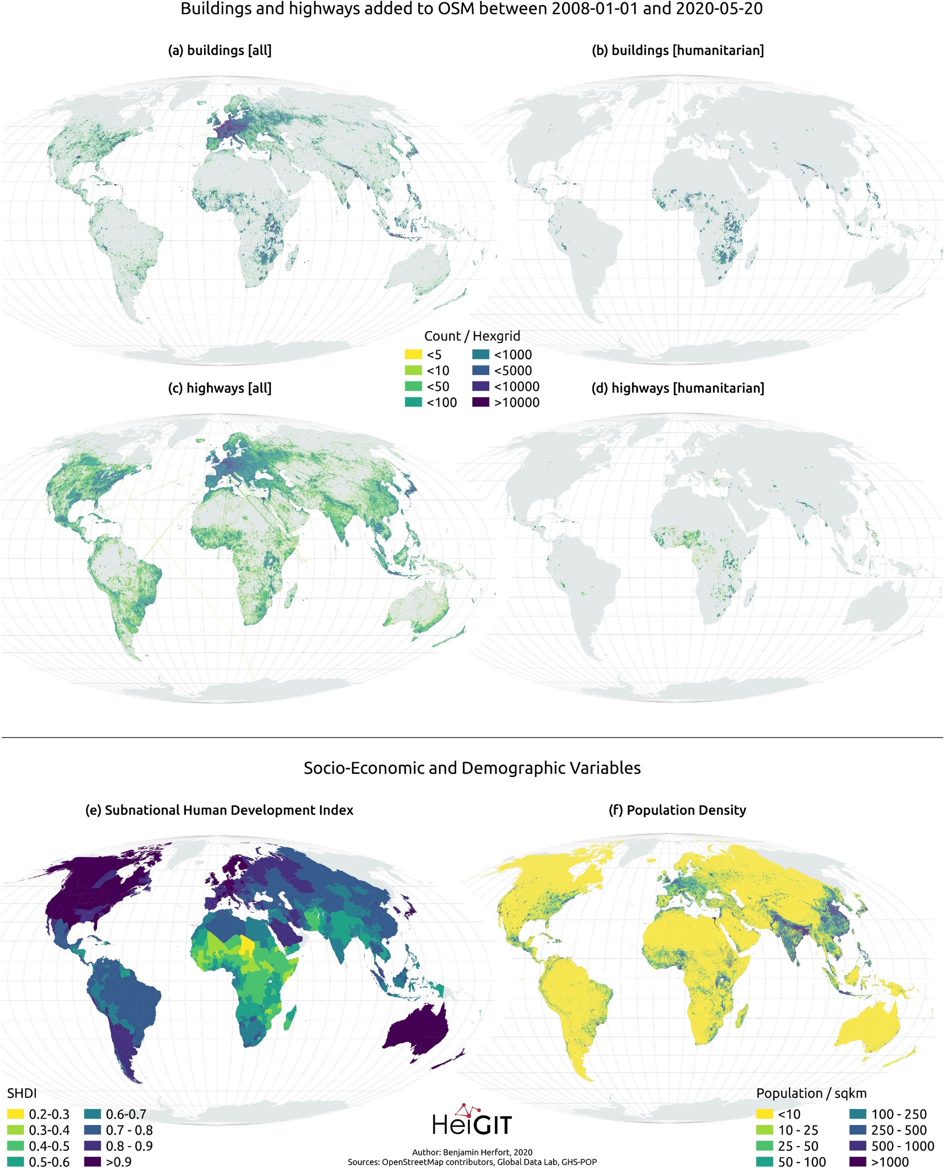
Spatial distribution of the number of buildings and highways added to OpenStreetMap between 2008-01-01 and 2020-05-20 in regard to overall and humanitarian mapping activities.
Summary
edit| Description |
English: Spatial distribution of the number of (a)–(b) buildings and (c)–(d) highways added to OSM between 2008/01/01 and 2020/05/20 in regard to overall and humanitarian mapping activities. Further the maps depict the spatial distribution of (e) SHDI and (f) population density. Note that population count (and not density) is used in the statistical models. Created using QGIS 3.10.8 (https://www.qgis.org/en/site/). |
| Date | |
| Source | Herfort, B., Lautenbach, S., Porto de Albuquerque, J. et al. The evolution of humanitarian mapping within the OpenStreetMap community. Sci Rep 11, 3037 (2021). doi:10.1038/s41598-021-82404-z |
| Author | Herfort, B., Lautenbach, S., Porto de Albuquerque, J. et al. (2021) |
| Other versions |
.png)
.png)
Licensing
edit
This file is licensed under the Creative Commons Attribution 4.0 International license.
- You are free:
- to share – to copy, distribute and transmit the work
- to remix – to adapt the work
- Under the following conditions:
- attribution – You must give appropriate credit, provide a link to the license, and indicate if changes were made. You may do so in any reasonable manner, but not in any way that suggests the licensor endorses you or your use.
File history
Click on a date/time to view the file as it appeared at that time.
| Date/Time | Thumbnail | Dimensions | User | Comment | |
|---|---|---|---|---|---|
| current | 14:56, 1 March 2021 | | 1,889 × 2,336 (2.54 MB) | Daniel Mietchen (talk | contribs) | Uploaded a work by Herfort, B., Lautenbach, S., Porto de Albuquerque, J. et al. (2021) from Herfort, B., Lautenbach, S., Porto de Albuquerque, J. et al. The evolution of humanitarian mapping within the OpenStreetMap community. Sci Rep 11, 3037 (2021). doi:10.1038/s41598-021-82404-z with UploadWizard |
You cannot overwrite this file.
File usage on Commons
The following 2 pages use this file:
- File:Maps of Subnational Human Development Index and Population Density - 41598 2021 82404 Fig2 (cropped).png
- File:Spatial distribution of the number of buildings and highways added to OpenStreetMap between 2008-01-01 and 2020-05-20 in regard to overall and humanitarian mapping activities - 41598 2021 82404 Fig2 (cropped).png