File:Speicher Zillergründl 08.jpg
Size of this preview: 799 × 323 pixels. Other resolutions: 320 × 129 pixels | 640 × 259 pixels | 1,024 × 414 pixels | 1,280 × 518 pixels | 2,560 × 1,035 pixels | 6,334 × 2,561 pixels.
Original file (6,334 × 2,561 pixels, file size: 13.51 MB, MIME type: image/jpeg)
Captions
Captions
Add a one-line explanation of what this file represents
| Description |
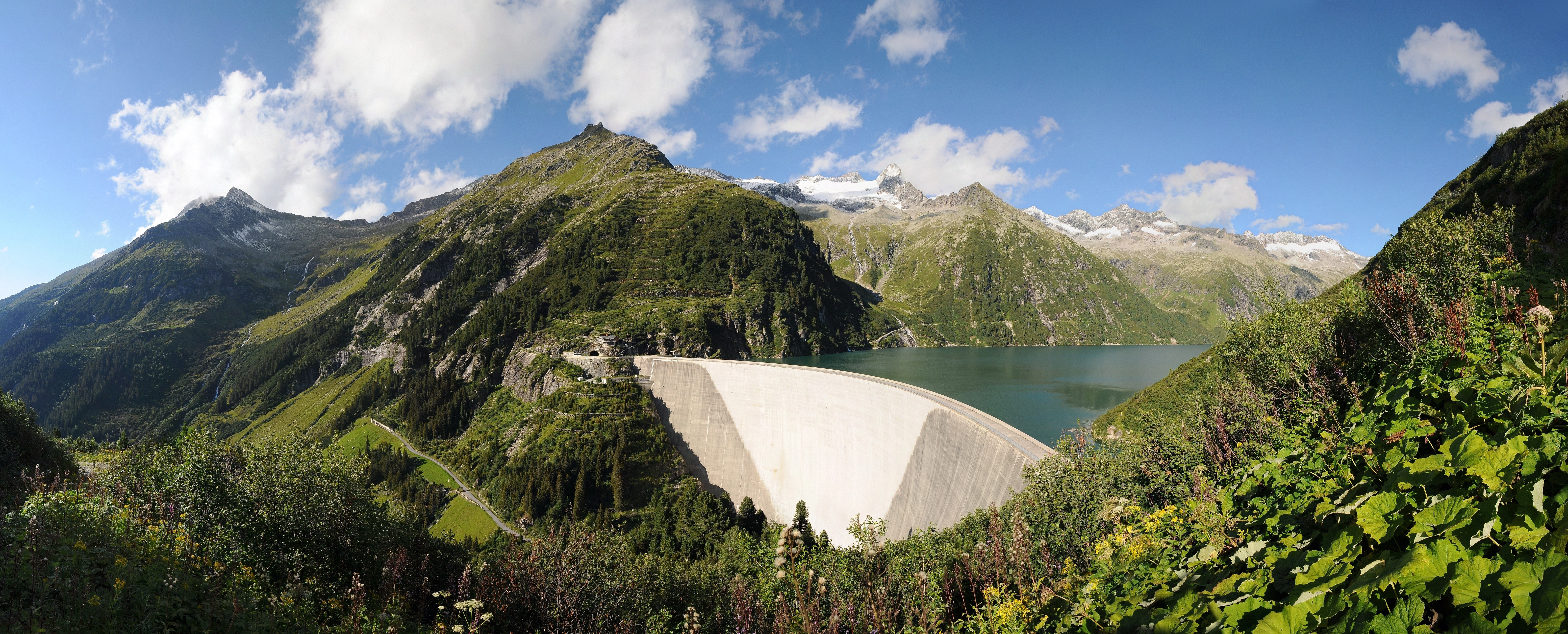
Deutsch: 1980 wurde mit dem Bau der Sperre Zillergründl begonnen. Das Sperrwerk ist als doppeltgekrümmte Bogengewichtsmauer ausgeführt. Das Wasser des Speichers fließt durch einen 8,6 Kilometer langen Triebwasserstollen zum Kraftwerk Häusling und nach der Stromerzeugung durch einen 7,8 Kilometer langen Stollen weiter zum Speicher Stillup. Erreichbar ist der Speichersee über eine 18 km lange Mautstraße, die für den öffentlichen Verkehr ab dem Gasthof Bärenbad (km 14) gesperrt ist, von hier aus ist die Staumauer nur mit dem Bus oder Rad (durch 2 Tunnels) erreichbar (km 18).
فارسی: سد تسیلرگروندل، یک سد بِتُنی قوسی است که بر روی رود زیلر در منطقهٔ بالادست دشت زیلر در ایالت تیرول اتریش ساخته شدهاست. نیروگاه این سد مجهز به نیروگاه تلمبه ذخیرهای است و توانایی تولید ۳۶۰ مگاوات برق مازاد بر مصرف را دارد. |
||
| Date | |||
| Source | Own work | ||
| Author |
|
||
| Permission (Reusing this file) |
I, the copyright holder of this work, hereby publish it under the following licenses:
This file is licensed under the Creative Commons Attribution-Share Alike 3.0 Austria license.
 You may select the license of your choice. |
||
| Other versions |
|


|
| Camera location | | View this and other nearby images on: OpenStreetMap |
|---|
File history
Click on a date/time to view the file as it appeared at that time.
| Date/Time | Thumbnail | Dimensions | User | Comment | |
|---|---|---|---|---|---|
| current | 21:39, 31 January 2013 | 6,334 × 2,561 (13.51 MB) | Böhringer (talk | contribs) | Shadow my assistant away. Reworked harsh light. Partially brightened. | |
| 11:33, 31 January 2013 | 6,334 × 2,561 (12.71 MB) | Böhringer (talk | contribs) | Fehler behoben | ||
| 20:57, 30 January 2013 | 6,334 × 2,561 (13.69 MB) | Böhringer (talk | contribs) | {{Information |Description= {{de|1980 wurde mit dem Bau der Sperre Zillergründl begonnen. Das Sperrwerk ist als doppeltgekrümmte Bogengewichtsmauer ausgeführt. Das Wasser des Speichers flie... |
You cannot overwrite this file.
File usage on Commons
The following 22 pages use this file:
- User:Böhringer
- User:Böhringer/Archive 5
- User:Miya/sandbox/FP/2013/Galleries/Table
- User:Ö/Best/2013
- Commons:Featured picture candidates/File:Speicher Zillergründl 08.jpg
- Commons:Featured picture candidates/Log/February 2013
- Commons:Featured pictures/Places/Natural/Austria
- Commons:Featured pictures/chronological/2013-A
- Commons:Picture of the Year/2013/Candidates
- Commons:Picture of the Year/2013/Galleries/Table
- Commons:Picture of the Year/2013/R1/Gallery/2013-A
- Commons:Picture of the Year/2013/R1/Gallery/ALL
- Commons:Picture of the Year/2013/R1/Gallery/M02
- Commons:Picture of the Year/2013/R1/Gallery/Nature views
- Commons:Picture of the Year/2013/R1/Results/Candidates
- Commons:Picture of the Year/2013/R1/v/Speicher Zillergründl 08.jpg
- File:Speicher Zillergründl 02.jpg
- File:Speicher Zillergründl 03.jpg
- File:Speicher Zillergründl 04.jpg
- File:Speicher Zillergründl 05.jpg
- File:Speicher Zillergründl 06.jpg
- File:Speicher Zillergründl 07.jpg
File usage on other wikis
The following other wikis use this file:
- Usage on de.wikipedia.org
- Usage on en.wikipedia.org
- Usage on fa.wikipedia.org
- Usage on fr.wikipedia.org
- Usage on hu.wikipedia.org
- Usage on mt.wikipedia.org
- Usage on sv.wikipedia.org
- Usage on vi.wikipedia.org