File:Spiš from Slavkovský štít.jpg

Size of this preview: 800 × 136 pixels. Other resolutions: 320 × 54 pixels | 640 × 109 pixels | 1,024 × 174 pixels | 1,280 × 217 pixels | 2,560 × 435 pixels | 16,554 × 2,812 pixels.
Original file (16,554 × 2,812 pixels, file size: 10.37 MB, MIME type: image/jpeg)
Captions
Captions
Add a one-line explanation of what this file represents
Summary edit
| Description |
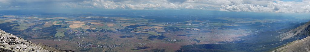
English: Spiš region, Slovakia as seen from Slavkovský štít, High Tatras. Slightly violet areas are forests destroyed by the wind.
Polski: Spisz widziany ze Sławkowskiego Szczytu. Tereny u podnóża gór o lekko fioletowej barwie, to łany wierzbówki kiprzycy rosnącej na wiatrołomach. |
| Date | |
| Source | Own work |
| Author | Marcin Białek |
| Camera location | | View this and other nearby images on: OpenStreetMap |
|---|
| This is a retouched picture, which means that it has been digitally altered from its original version. Modifications: panorama made of 18 pictures merged with autostich.
|
Licensing edit
I, the copyright holder of this work, hereby publish it under the following licenses:

|
Permission is granted to copy, distribute and/or modify this document under the terms of the GNU Free Documentation License, Version 1.2 or any later version published by the Free Software Foundation; with no Invariant Sections, no Front-Cover Texts, and no Back-Cover Texts. A copy of the license is included in the section entitled GNU Free Documentation License. |
This file is licensed under the Creative Commons Attribution-Share Alike Attribution-Share Alike 4.0 International, 3.0 Unported, 2.5 Generic, 2.0 Generic and 1.0 Generic license.
- You are free:
- to share – to copy, distribute and transmit the work
- to remix – to adapt the work
- Under the following conditions:
- attribution – You must give appropriate credit, provide a link to the license, and indicate if changes were made. You may do so in any reasonable manner, but not in any way that suggests the licensor endorses you or your use.
- share alike – If you remix, transform, or build upon the material, you must distribute your contributions under the same or compatible license as the original.
You may select the license of your choice.
File history
Click on a date/time to view the file as it appeared at that time.
| Date/Time | Thumbnail | Dimensions | User | Comment | |
|---|---|---|---|---|---|
| current | 09:54, 25 July 2008 | 16,554 × 2,812 (10.37 MB) | Sfu (talk | contribs) | {{Information |Description={{en|1=Spiš region, Slovakia as seen from Slavkovský štít, High Tatras. Slightly violet areas are forests destroyed by the wind.}} {{pl|1=Spisz widziany ze [[:pl:Sławko |
You cannot overwrite this file.
File usage on Commons
The following page uses this file: