File:Spice Islands (Tanzania).svg

Size of this PNG preview of this SVG file: 486 × 599 pixels. Other resolutions: 195 × 240 pixels | 389 × 480 pixels | 623 × 768 pixels | 831 × 1,024 pixels | 1,661 × 2,048 pixels | 713 × 879 pixels.
Original file (SVG file, nominally 713 × 879 pixels, file size: 15 KB)
Captions
Captions
Add a one-line explanation of what this file represents
Summary
edit.svg&action=edit§ion=1)
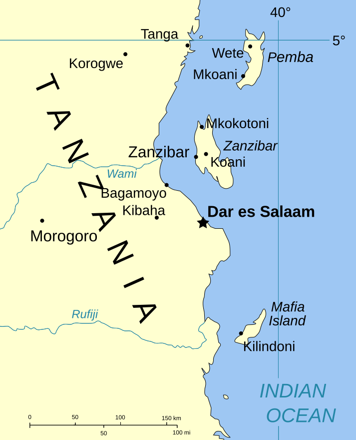
| Description | Part of the map of Tanzania, showing the Spice Islands. |
| Date | |
| Source | Vectors self-made in Inkscape. Source was cropped from http://www.lib.utexas.edu/maps/africa/tanzania_pol_2003.jpg which is said to be in the public domain in the Perry-Castañeda Map Collection FAQ. |
| Author | Mysid |
| Permission (Reusing this file) |
PD |
| Other versions |
Image:Spice Islands (Zanzibar highlighted).svg in French : Image:Spice_Islands_Tanzania-fr.svg in French : Image:Spice_Islands-Zanzibar_highlighted-fr.svg |
.svg)
Licensing
edit.svg&action=edit§ion=2)
| I, the copyright holder of this work, release this work into the public domain. This applies worldwide. In some countries this may not be legally possible; if so: I grant anyone the right to use this work for any purpose, without any conditions, unless such conditions are required by law. |
File history
Click on a date/time to view the file as it appeared at that time.
| Date/Time | Thumbnail | Dimensions | User | Comment | |
|---|---|---|---|---|---|
| current | 20:01, 6 January 2007 | | 713 × 879 (15 KB) | Mysid (talk | contribs) | (a bit more) standard colors |
| 06:44, 29 May 2006 |  | 713 × 879 (20 KB) | Mysid (talk | contribs) | corrected buggy scale | |
| 06:40, 29 May 2006 |  | 713 × 879 (20 KB) | Mysid (talk | contribs) | New version, exported from CorelDraw (inkscape seems buggy) | |
| 18:23, 28 May 2006 |  | 713 × 893 (37 KB) | Mysid (talk | contribs) | {{Information |Description=Part of the map of Tanzania, showing the Spice Islands. |Source=Vectors self-made in Inkscape. Source was cropped from http://www.lib.utexas.edu/maps/africa/tanzania_pol_2003.jpg which is said to be in the pu |
You cannot overwrite this file.
File usage on Commons
The following 3 pages use this file:
File usage on other wikis
The following other wikis use this file:
- Usage on ckb.wikipedia.org
- Usage on da.wikipedia.org
- Usage on eo.wikipedia.org
- Usage on eu.wikipedia.org
- Usage on fa.wikipedia.org
- Usage on fo.wikipedia.org
- Usage on fr.wikipedia.org
- Usage on hr.wikipedia.org
- Usage on it.wikipedia.org
- Usage on ja.wikipedia.org
- Usage on mi.wikipedia.org
- Usage on nl.wikipedia.org
- Usage on no.wikipedia.org
- Usage on pt.wikipedia.org
- Usage on sr.wikipedia.org
- Usage on sv.wikipedia.org
- Usage on vi.wikipedia.org
- Usage on zh.wikipedia.org
.svg&oldid=897782045)