File:St. Matthias' Parish Church, Bleary Road, Knocklnamuckley - geograph.org.uk - 504873.jpg
No higher resolution available.
St._Matthias'_Parish_Church,_Bleary_Road,_Knocklnamuckley_-_geograph.org.uk_-_504873.jpg (640 × 480 pixels, file size: 67 KB, MIME type: image/jpeg)
Captions
Captions
Add a one-line explanation of what this file represents
Summary
edit
| Description |
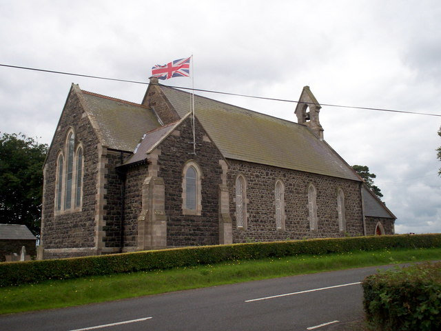
English: St. Matthias' Parish Church, Bleary Road, Knocklnamuckley In the townland of Ballygargan, Knocknamuckley church was constituted as a perpetual curacy on the 27th October 1837 out of the existing parishes of Seagoe and Tullylish. It opened for worship in 1853. Initially only the nave was built, the chancel and organ chamber being added in 1912. A small porch was replaced by a larger structure in 1987 to mark the 150th anniversary of the parish. Knocknamuckley has no stained glass. This parish, whose name in Irish is Cnoc-na-muice-laith signifies the Hill of the Grey Pig. |
| Date | |
| Source | From geograph.org.uk |
| Author | P Flannagan |
| Attribution (required by the license) | P Flannagan / St. Matthias' Parish Church, Bleary Road, Knocklnamuckley / |
| Object location | | View this and other nearby images on: OpenStreetMap |
|---|
_heading:225.00&language=en)
Licensing
edit

|
This image was taken from the Geograph project collection. See this photograph's page on the Geograph website for the photographer's contact details. The copyright on this image is owned by P Flannagan and is licensed for reuse under the Creative Commons Attribution-ShareAlike 2.0 license.
|
This file is licensed under the Creative Commons Attribution-Share Alike 2.0 Generic license.
Attribution: P Flannagan
- You are free:
- to share – to copy, distribute and transmit the work
- to remix – to adapt the work
- Under the following conditions:
- attribution – You must give appropriate credit, provide a link to the license, and indicate if changes were made. You may do so in any reasonable manner, but not in any way that suggests the licensor endorses you or your use.
- share alike – If you remix, transform, or build upon the material, you must distribute your contributions under the same or compatible license as the original.
- Remove redundant categories and try to put this image in the most specific category/categories
- Remove this template
- The location categories are based on information from this geonames tool and this OpenStreetMap tool combined with a database. You can also have a look at this tool from mysociety.
- The topic category from Geograph was Church (Church of Ireland) (find similar images (Church of Ireland) at Geograph)
File history
Click on a date/time to view the file as it appeared at that time.
| Date/Time | Thumbnail | Dimensions | User | Comment | |
|---|---|---|---|---|---|
| current | 10:11, 5 February 2011 | | 640 × 480 (67 KB) | GeographBot (talk | contribs) | == {{int:filedesc}} == {{Information |description={{en|1=St. Matthias' Parish Church, Bleary Road, Knocklnamuckley In the townland of Ballygargan, Knocknamuckley church was constituted as a perpetual curacy on the 27th October 1837 out of the existing par |
You cannot overwrite this file.
File usage on Commons
There are no pages that use this file.