File:StThomas'sChurch Exeter 1765Map BenjaminDonne.png

Size of this preview: 664 × 600 pixels. Other resolutions: 266 × 240 pixels | 531 × 480 pixels | 850 × 768 pixels | 1,133 × 1,024 pixels | 2,267 × 2,048 pixels | 2,652 × 2,396 pixels.
Original file (2,652 × 2,396 pixels, file size: 10.68 MB, MIME type: image/png)
Captions
Captions
Add a one-line explanation of what this file represents
Summary
edit
| Description |
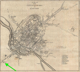
English: St Thomas's Church, indicated by green arrow (2016) on 1765 map of the City of Exeter by Benjamin Donne |
| Date | |
| Source | File:Plan of the City and Suburbs of Exeter,1765.jpg |
| Author | Map by BenjaminDonne, 1765. Green arrow added by Lobsterthermidor (talk) 11:56, 31 October 2017 (UTC). |
Licensing
edit
This file is licensed under the Creative Commons Attribution-Share Alike 3.0 Unported license.
- You are free:
- to share – to copy, distribute and transmit the work
- to remix – to adapt the work
- Under the following conditions:
- attribution – You must give appropriate credit, provide a link to the license, and indicate if changes were made. You may do so in any reasonable manner, but not in any way that suggests the licensor endorses you or your use.
- share alike – If you remix, transform, or build upon the material, you must distribute your contributions under the same or compatible license as the original.
File history
Click on a date/time to view the file as it appeared at that time.
| Date/Time | Thumbnail | Dimensions | User | Comment | |
|---|---|---|---|---|---|
| current | 11:56, 31 October 2017 | | 2,652 × 2,396 (10.68 MB) | Lobsterthermidor (talk | contribs) | {{Information |Description ={{en|1=St Thomas's Church, indicated by green arrow (2016) on 1765 map of the City of Exeter by Benjamin Donne}} |Source =File:Plan of the City and Suburbs of Exeter,1765.jpg |Author =Map by BenjaminDonne,... |
You cannot overwrite this file.
File usage on Commons
There are no pages that use this file.
File usage on other wikis
The following other wikis use this file:
- Usage on en.wikipedia.org
- Usage on zh-yue.wikipedia.org